Category One Hurricane is an “Extreme Worst-Case Scenario”

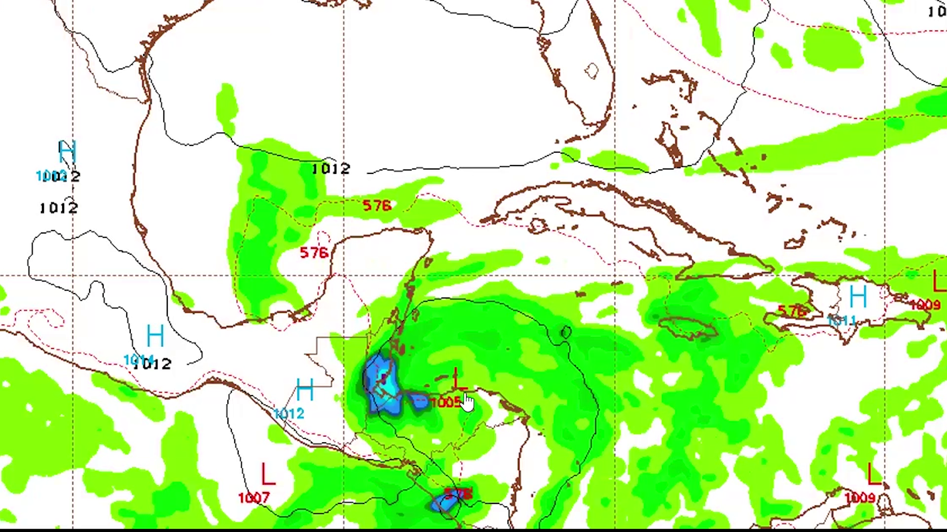
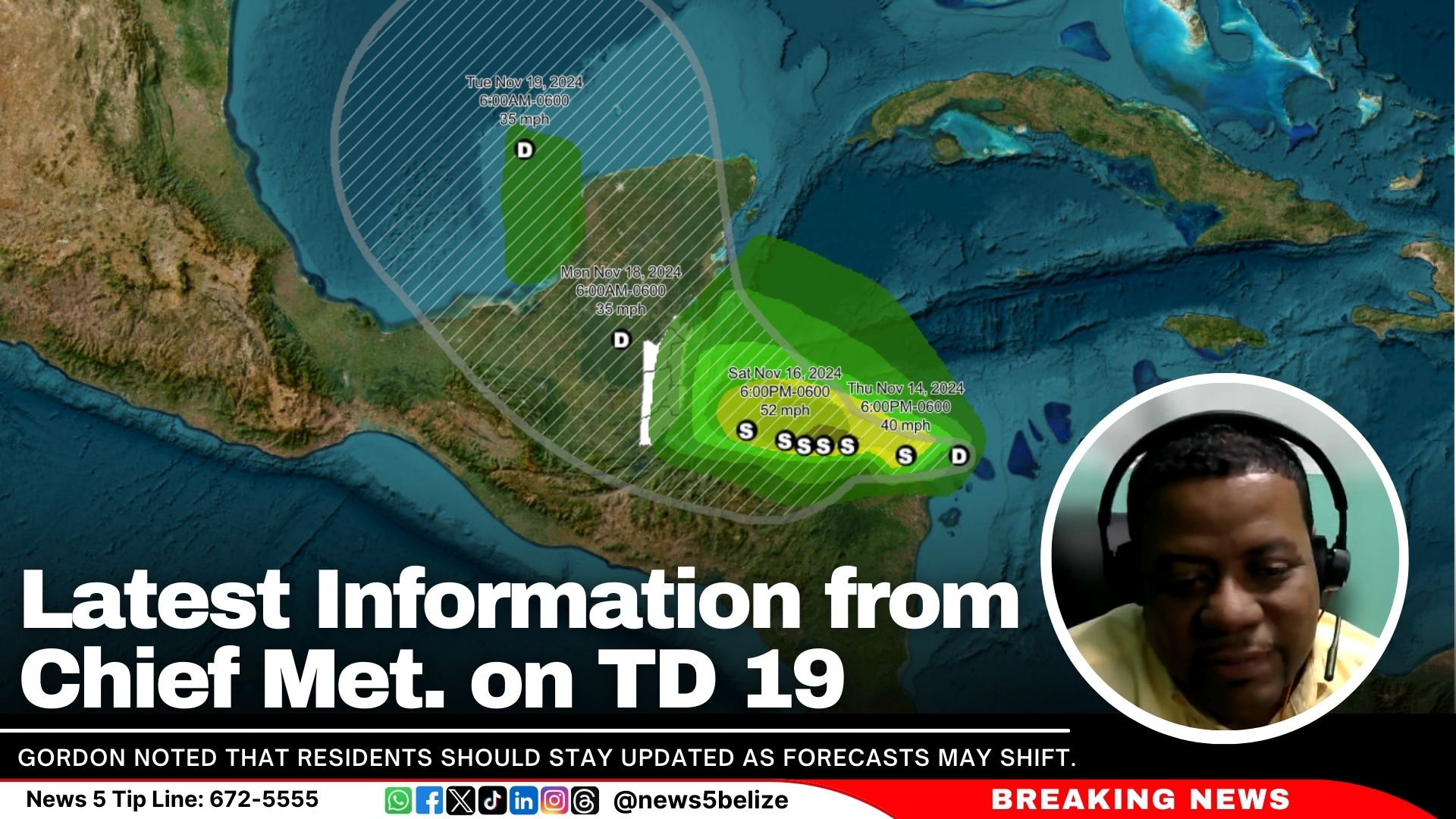
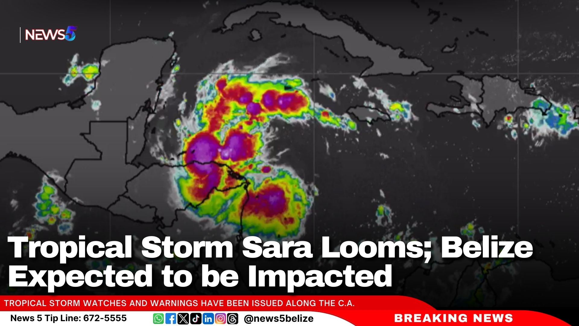
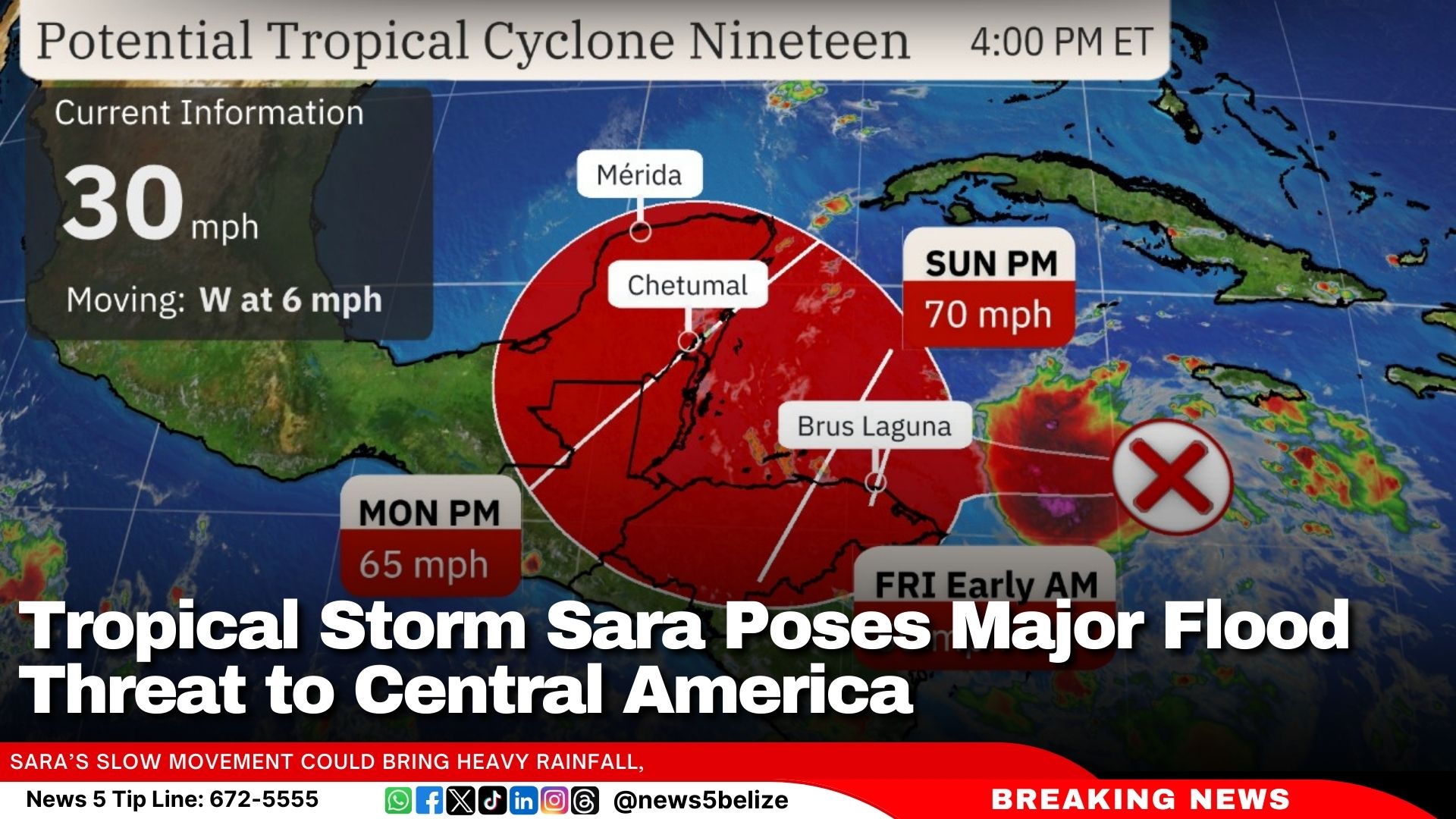
Once again, the projected path has shifted further south. NEMO now predicts that Sara will strengthen, with maximum sustained winds of around 50 miles per hour when it makes landfall in Belize. The worst-case scenario, according to Gordon, is that Sara could become a category one hurricane. He shared this information with reporters this morning but emphasized that there’s still a lot of uncertainty with these projections.


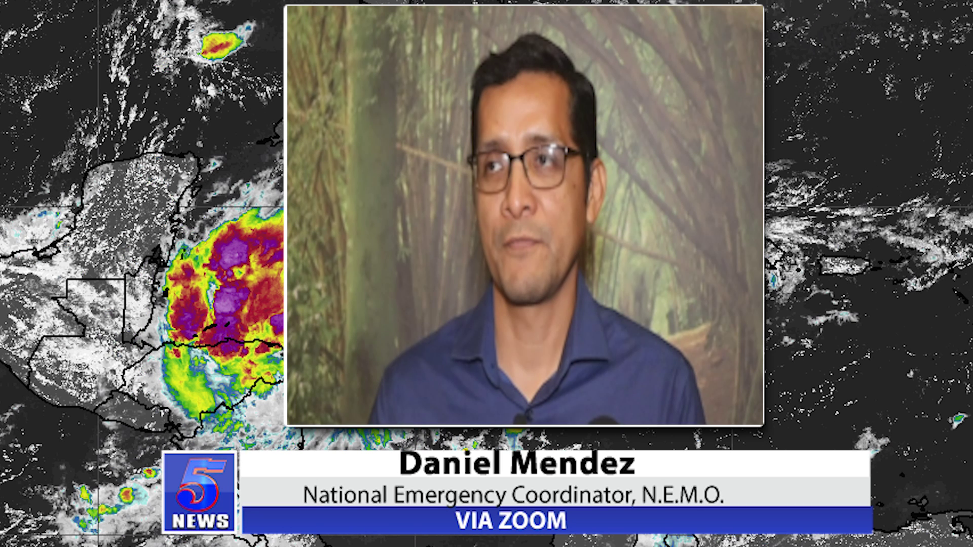
Ronald Gordon, Chief Met Officer

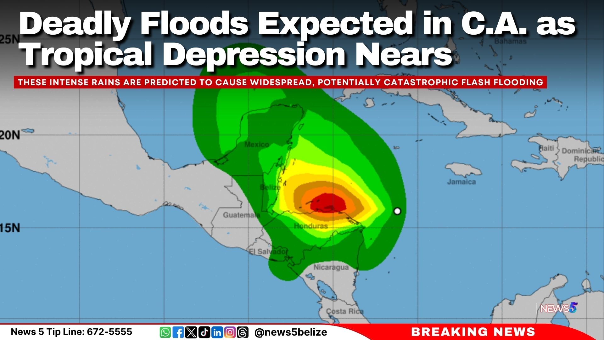
“There is no exact tract. There is a cone. So, the system can pass anywhere within that cone. As I had indicated, it is a probability distribution. So, the highest probability is within the center of that cone. But that is not a hundred percent. If it was a hundred percent, we would not have a cone. It will have a line showing it is going there. So, it can change. That is the long and short of the answer. However, it is most likely to impact the country at the center of that cone. In terms of intensity, again that is not as certain. Not of the factors that could prevent further strengthening is interaction with land. As I showed the system is forecasted to move close to land, to Honduras and if it jogs even a bit further south it will weaken even further. However, if it remains offshore, it will be a bit stronger. There are still some variants within that intensity forecast. Currently the forecast is for it to come assure as a fifty-mile-per-hour storm and that is down from yesterday when they had it at seventy. That means more of the models are showing it weakening over land in Honduras. The extreme worst case scenario outside of the forecast right now is perhaps a category one hurricane. We are not seeing that, but that is the extreme worst.”


TS Sara to Dump Heavy Rains Over Belize

One thing is for sure—Belize is in for some heavy rainfall. Projections for Tropical Storm Sara suggest that the country could see up to ten inches of rain over the next three days. Chief Hydrologist Tenielle Hendy has issued flood warnings for four rivers across the country. Areas already dealing with floods, like San Roman and San Antonio, are likely to face even greater flood threats. Hendy shared more details with us.


                    Tenielle Hendy

Tenielle Hendy, Chief Hydrologist

“We do have a flood warning still in effect for the Mopan, Macal, Rio Hon and Belize Rivers. Some of the roads in the north are still impassable. In region seven, even though it is at flood stage levels, it is decreasing at the moment. In region nine we have the Mopan and Belize rivers still at flood stage and the three dam facilities, the spillways are still active. A departure from the forecast yesterday is that we are now seeing the Sibun River exhibiting or reflecting increasing above normal levels. Looking ahead into the outlook, for our stream flow. We are noticing this stream as per this flood forecast. It is just showing above level conditions. But this will change with the introduction of the rainfall. Moving into what is expected based on the current time step of TD. With the estimated accumulation of ten inches of rainfall over a five-day period, what we can expect that we will be seeing is flooding in those areas that will be affected, the areas that are already flooded. If you receive additional rainfall, we can see the extent widening in these areas and when it cannot spread out anymore, the extent it will go deeper.”


Will TS Sara’s Projected Path Lead to Business Closures?

So, will NEMO open hurricane shelters this weekend? And what about businesses—will they close while the storm passes? During Tropical Storm Nadine a few weeks ago, many employers still required their employees to come in, and several street vendors stayed open. Today, National Emergency Coordinator Daniel Mendez explained that shelters are prepped and ready to open, but only Prime Minister Briceño has the authority to call off work.


Via Zoom: Daniel Mendez, National Emergency Coordinator, N.E.M.O

“Again, the shelters will be opened as necessary. This is one of the actions that each district committee makes on their own. The EOCs are meeting. They understand the different peculiarities of their own districts. So, when there is a need to open the shelters, these will be opened and made known to the public. In terms of determining the closure of businesses, these are major conversations that need to be had. While I can say I do not have the final say, it does not mean I am not providing advice to the chairman of N.E.M.O who is the prime minister. These are major determinations that need to be made. There is always a need to try to find a balance between public safety and the need to keep things going. We did see that happen in Tropical Storm Nadine. We did our best to make those known that the decision was this was a very quick storm, and it was very challenging to provide that advice.”


NEMO Prepares for TS Sara Impact

National Emergency Coordinator, Daniel Mendez, provided an update on the National Emergency Management Organization’s (NEMO) preparations in response to Tropical Storm Sara.

Heavy rainfall is expected to cause life-threatening flash flooding and mudslides across parts of Central America, especially in Honduras, Belize, El Salvador, eastern Guatemala, and western Nicaragua, through early next week. Tropical storm conditions are likely along the northern coast of Honduras and the Bay Islands, where warnings are in effect. The system is forecast to approach Belize and Mexico’s Yucatan Peninsula by early next week, bringing a risk of strong winds, and residents should stay updated on the latest forecasts. It remains uncertain whether the system will impact the eastern Gulf of Mexico, including Florida, later next week, so residents there should also monitor forecast updates.

Mendez outlined that all emergency operation centres across the country are being prepared, with emergency committees meeting to discuss operational plans and needs. NEMO is preparing for heavy rainfall and strong winds that could lead to flooding in various parts of the country.

He said NEMO’s ongoing operations, which have included providing support to flood-prone areas. Mendez shared that NEMO is currently assisting two villages—San Roman in the Rio Hondo and San Antonio—which have been impacted by flooding. Access to these areas is currently restricted, so NEMO has been using boats and vehicles, including those provided by the Belize Defence Force, to ferry residents across flooded zones.

Mendez also mentioned that water levels are rising in the village of Douglas, where two families are sheltering. NEMO is continuing its support with ferrying workers and students in the San Roman and Santa Cruz areas.

Mendez urged the public to remain vigilant and prepared, particularly those living in flood-prone areas. He stressed that while the country is still in the hurricane season, NEMO is fully operational and ready to respond in coordination with all levels of government and partners.

Latest Information from Chief Met. on TD 19 

Flood Warnings Still in Effect

In today’s briefing, Chief Hydrologist Tennielle Hendy provided an update on the ongoing flooding across Belize, with warnings still in effect for several rivers. 

“We do have a flood warning still in effect for the Rio Hondo, Makal, Maupan, and Belize rivers,” Hendy confirmed. “Some of the roads in the north are still impassable.”

While some regions have seen improvements, such as a decrease in flood levels in Region 7, Hendy stated that other areas remain at risk. “In Region 9, we have the Mopan and the Belize rivers still at bankfull or flood stage,” she said, adding, “the spillways at the tree dam facilities are still active.”

Hendy added: “A departure from the flood forecast issued yesterday is that we’re now seeing that the Saboon River is exhibiting increasing above-normal levels for the remainder of the country.”

She warned that conditions could change rapidly with rainfall. “We expect that with rainfall, the situation will change,” she said. “These are models… they are based on a living, moving, breathing environment, and it can change.”

Regarding flash flooding, Hendy explained the current soil moisture levels, which are moderate but could lead to increased risk. Regarding Tropical Depression Nineteen, she stated that it is expected to bring up to 10 inches of rain over the next five days. She warned, “If you receive additional rainfall, we can see the extent widening in these areas,” and advised the public to continue monitoring the weather from reliable sources.


Latest Information from Chief Met. on TD 19 

Latest Information from Chief Met. on TD 19 

During a press briefing this morning, Chief Meteorologist Ronald Gordon addressed the potential impacts of Tropical Depression Nineteen, which is currently located in the western Caribbean. According to Gordon, there’s a less than 20% probability of tropical storm-force winds reaching Belize within the next five days, though this could increase as the system intensifies. “That low probability doesn’t rule it out entirely,” he explained, “but for now, based on the forecast, it’s low.”

Gordon shared satellite imagery showing that the system, though disorganised, is becoming better structured, with banding features forming near the Gulf of Honduras. As of the latest update, the system is moving west at 14 mph, with maximum sustained winds of 35 mph and a central pressure of 1004 mb. It is approximately 391 miles east-southeast of Belize City, with a projected arrival in Belize’s vicinity within 27 hours if it maintained its speed. However, the system is forecast to slow down and potentially stall north of Honduras for 24 to 36 hours before shifting northwest.

Gordon pointed out that while models offer different scenarios, each one predicts significant rainfall for Belize, with some areas potentially seeing more than 10 inches by Monday. While the American model shows the system weakening due to land interaction, the European model suggests it could intensify slightly as it stalls near the Honduran coast.

Gordon noted that residents should stay updated as forecasts may shift. Regardless of its final intensity, the system is likely to bring widespread heavy rainfall, and there’s a significant chance of a tropical storm impacting Belize late Sunday into Monday.

Gordon reminded residents that models have inherent inaccuracies and assumptions, adding, “No forecast can be precise. There is a high probability of landfall in Belize, but focus less on exact timing—rainfall could precede the storm’s arrival.”

Key Updates on Tropical Depression 19

Tropical Storm Sara Looms; Belize Expected to be Impacted 

Tropical Depression Nineteen, poised to become Tropical Storm Sara, is advancing through the western Caribbean Sea and is expected to bring a potentially catastrophic flood threat to Central America over the coming days. Currently located over 200 miles east-southeast of Isla Guanaja, Honduras, the depression has sustained winds of 35 mph and is moving westward at 14 mph.

Tropical storm watches and warnings have been issued along the Central American coast, with conditions expected within 36 to 48 hours. The system is forecasted to strengthen in the Caribbean’s warm waters, although land interaction near Honduras, Belize, and Mexico’s Yucatán Peninsula could limit its intensity.

Regardless of Sara’s ultimate strength, the storm’s anticipated slow movement across the region is expected to bring torrential rainfall and widespread flash flooding. Northern Honduras could experience up to 30 inches of rain, while Belize, Nicaragua, and surrounding areas may see up to 15 inches, increasing the risk of mudslides and severe flooding.

Deadly Floods Expected in C.A. as Tropical Depression Nears

Deadly Floods Expected in C.A. as Tropical Depression Nears

Tropical Depression 19 has formed in the southwestern Caribbean Sea and is forecasted to become Tropical Storm Sara soon. The system is expected to move westward and stall near Honduras before heading northward next week.

The National Hurricane Center issued an early morning advisory warning that Tropical Depression Nineteen poses a severe flooding threat to parts of Central America, especially Honduras. The storm, located approximately 250 miles east of Isla Guanaja, Honduras, and about 90 miles northeast of Cabo Gracias a Dios on the Nicaragua-Honduras border, is expected to bring torrential rains and life-threatening flash flooding to the region over the weekend.

Moving west at 15 mph with sustained winds of 35 mph, the depression is forecast to strengthen into a tropical storm later today if it remains over water.

A Hurricane Watch is in effect for the Bay Islands of Honduras and from Punta Castilla to the Honduras-Nicaragua border, indicating that hurricane conditions could develop within the next 48 hours. Tropical Storm Warnings are also in place for the same areas, with conditions expected within 36 hours, while a Tropical Storm Watch extends from the Honduras-Nicaragua border to Puerto Cabezas.

Rainfall totals could reach 10 to 20 inches in northern Honduras, with isolated areas expecting up to 30 inches. These intense rains are predicted to cause widespread, potentially catastrophic flash flooding and mudslides, particularly near the Sierra La Esperanza. Other areas, including Belize, El Salvador, eastern Guatemala, and western Nicaragua, may see rainfall between 5 to 10 inches, with some locations receiving up to 15 inches, also heightening the risk of flash floods and landslides.

Residents in the affected areas are advised to closely monitor updates and prepare for significant impacts, as the system is likely to linger near Honduras’ northern coast through the weekend, bringing destructive waves and potentially raising water levels by up to three feet along the immediate coastline.

https://edition.channel5belize.com/tropical-storm-sara-poses-major-flood-threat-to-central-america/

Mayor Says CEMO Monitoring Approaching Tropical Storm

Tropical Storm Sara is brewing and could start moving westward next week. If it forms, it’ll be the eighteenth named storm of this Atlantic Hurricane Season. Right now, it’s expected to head towards the Gulf of Mexico, but we’re still not sure how strong it’ll get or its exact path. The National Emergency Management Organization is ready, and today, Belize City Mayor Bernard Wagner mentioned that CEMO is also keeping a close eye on Sara’s progress and power.


Bernard Wagner, Mayor, Belize City

“Our city emergency NEMO. and the Met Office and we are closely monitoring, the track of this system here. But we stand ready as a city. We hope it never comes to fruition. We never want to be impacted by any hurricane or disaster. Because the fact is that, it really sets you back as a country, and especially as a municipality that has its own struggles.”


Tropical Storm Sara Poses Major Flood Threat to Central America

The Atlantic hurricane season’s 18th named storm, Tropical Storm Sara, is projected to form in the western Caribbean and potentially move towards the Gulf of Mexico by next week. However, the storm’s exact path remains uncertain. A low-pressure system, located in the Caribbean between Jamaica, Honduras, and Nicaragua, is expected to develop into Sara. Designated as Potential Tropical Cyclone Nineteen, this classification allows the National Hurricane Center (NHC) to issue alerts in advance.

The NHC has scheduled a Hurricane Hunter flight to investigate the storm. Tropical storm and hurricane watches and warnings are in place for parts of Central America, indicating possible severe weather within 36-48 hours.

Sara could intensify over warm Caribbean waters and low wind shear. If it stays over open water, it may reach hurricane status; however, it could also move closer to land, affecting areas like Honduras, Belize, or Mexico’s Yucatan Peninsula.

Sara’s slow movement could bring heavy rainfall, risking catastrophic flooding and mudslides in Central America.

Models suggest Sara could head north towards the Gulf by Tuesday, potentially reaching Florida or western Cuba by Wednesday as it meets a cold front. Forecasts vary, and Sara could range from a weaker storm to a powerful tropical system.

.

Exit mobile version