High Chance of Tropical Storm Sara Forming in Caribbean

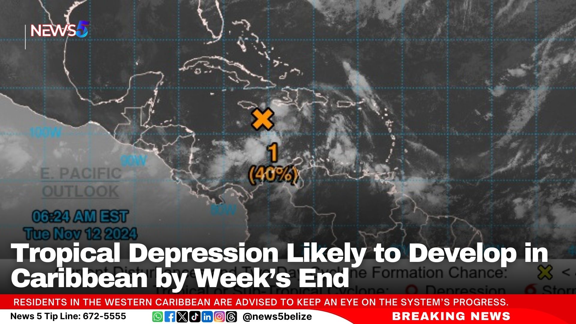
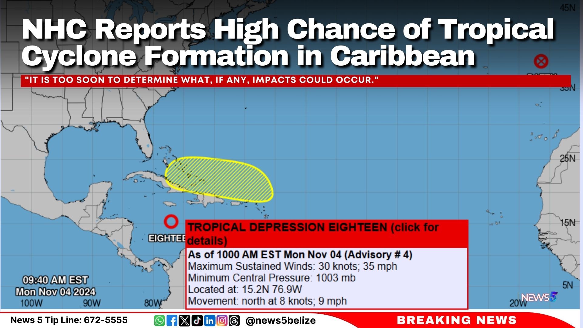
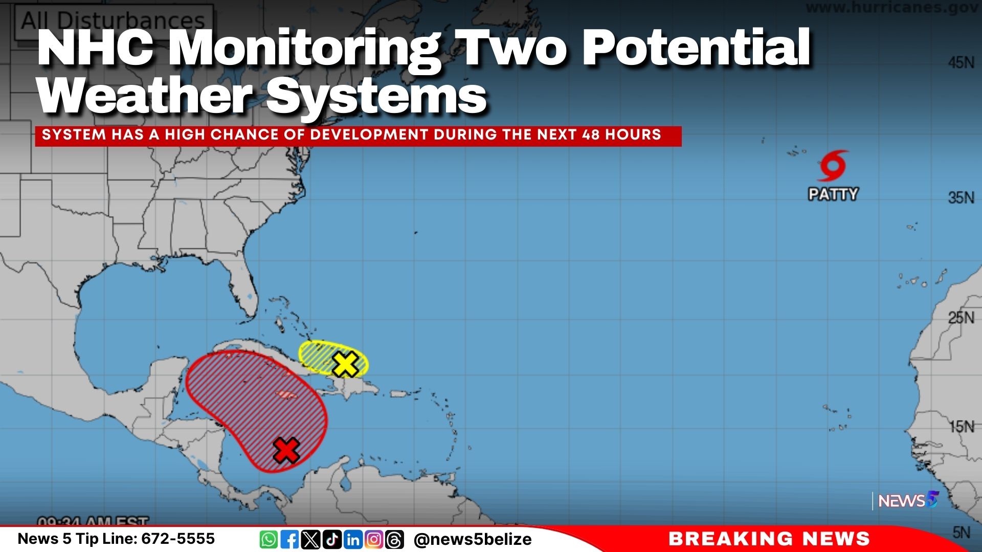
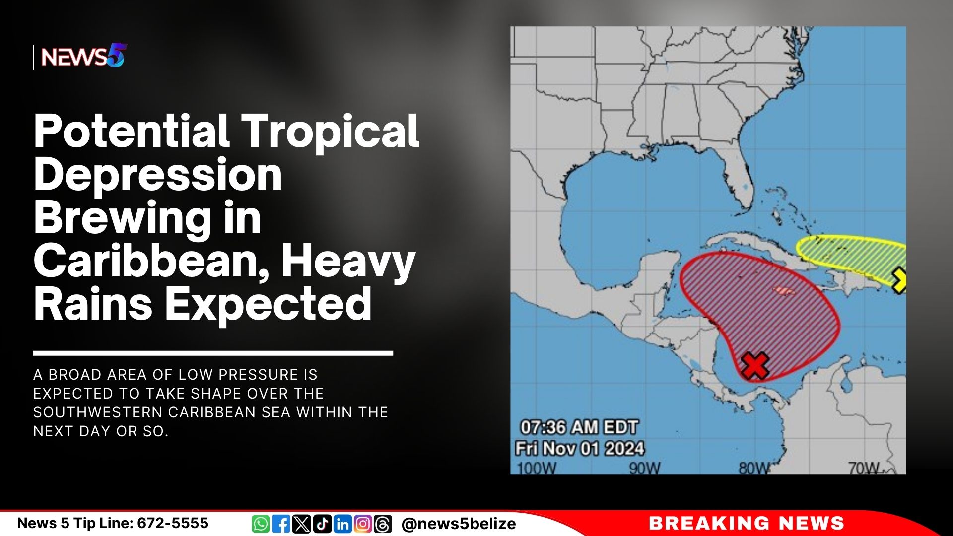
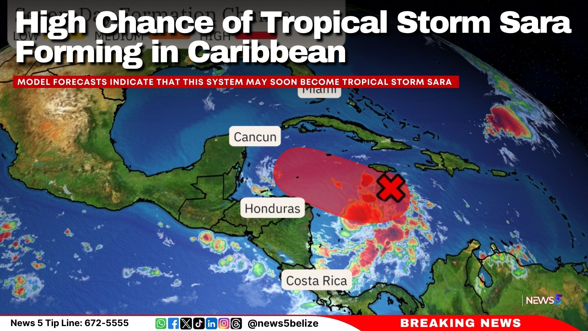
The National Meteorological Service is closely monitoring a broad low-pressure system over the central Caribbean Sea, which continues to produce extensive showers and thunderstorms. This system, referred to as Invest 99L, has a high chance of developing into a tropical system within the next 48 hours as it moves slowly westward toward the western Caribbean Sea.

As the Atlantic hurricane season nears its end, this development could lead to the formation of the season’s 18th named storm, future Sara, possibly heading toward the Gulf of Mexico next week. However, the track and intensity remain highly uncertain.

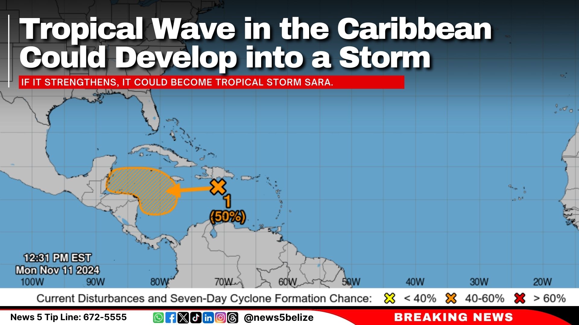
Model forecasts indicate that this system may soon become Tropical Storm Sara once it strengthens into a depression later this week. With favorable conditions, such as low wind shear and record-warm waters for mid-November, it could potentially strengthen to hurricane status in the western Caribbean.

While the track remains complicated and subject to change, the system is expected to move slowly westward toward Central America and the Yucatán Peninsula through early next week. This slow movement could result in heavy rainfall and potential flash flooding or mudslides in the region.

Forecast models show that a cold front moving across the U.S. might influence its path, potentially pulling it northward toward the Yucatán, the southern Gulf of Mexico, or western Cuba by Monday or Tuesday. There is a possibility that this cold front could then accelerate its movement eastward, possibly affecting Florida or Cuba by mid-week.

Tropical Depression Likely to Develop in Caribbean by Week’s End

The National Hurricane Center reports that a tropical wave in the central Caribbean Sea is generating disorganised showers and thunderstorms, with environmental conditions favourable for development. Forecasters anticipate that this system could strengthen into a tropical depression by the end of the week as it gradually moves westward into the western Caribbean.

After reaching the western Caribbean, the disturbance is expected to slow down and linger over the area throughout the weekend before shifting northwestward early next week. Residents in the western Caribbean are advised to keep an eye on the system’s progress.

Chance of formation within 48 hours: 40%
Chance of formation within 7 days: 80%

If it strengthens, it could become Tropical Storm Sara.

Tropical Wave in the Caribbean Could Develop into a Storm

The National Hurricane Centre (NHC) is closely monitoring an area of disorganised showers and thunderstorms in the central Caribbean Sea, south of Hispaniola. The system is expected to move slowly westward over the next few days. 

The NHC reported that “environmental conditions appear conducive for gradual development,” giving the system 50% chance of development in the next seven days.

Forecasters say it could form later this week or over the weekend. If it strengthens, it could become Tropical Storm Sara.

Hurricane Rafael Strikes Gulf of Mexico as Category 3 Storm

As of this morning, Hurricane Rafael remains a powerful Category 3 storm, sustaining winds of 120 mph, says the National Hurricane Centre. The 17th named storm is moving across the Gulf of Mexico as one of the strongest hurricanes to form in the region during this late season. While it is expected to weaken over the weekend, it may still produce tropical storm-force winds and dangerous surf across the Gulf Coast and threaten the southern United States.

The hurricane has already caused significant damage in Cuba, where millions of people are still without power after the storm knocked out the country’s entire power grid. Cuban President Miguel Díaz-Canel visited the affected areas, and more than 283,000 people were evacuated due to the storm, with large numbers coming from the capital Havana.

The NHC advises those living along the Gulf Coast to stay updated on forecasts and prepare for possible impacts as Rafael continues its path.

Hurricane Rafael Moves into Gulf of Mexico

Hurricane Rafael, which struck Cuba on Wednesday as a powerful Category 3 storm, has caused significant damage to the island’s power grid. “The national electric system collapsed due to strong winds,” said Félix Estrada Rodríguez, director of Cuba’s Electric Union. The storm brought down power poles and disrupted services.

Rafael has weakened to a Category 2 hurricane as it moves westward into the Gulf of Mexico. While its path no longer threatens the U.S., the storm poses an increasing risk to Mexico’s Gulf Coast. The National Hurricane Centre now predicts the storm will stay over the southern Gulf for several days before weakening further.

Chevron, Shell, and BP have all taken precautions by evacuating personnel from oil rigs in the Gulf as Rafael moves closer.

NHC Reports High Chance of Tropical Cyclone Formation in Caribbean

The National Hurricane Centre (NHC) is currently monitoring two active weather systems in the Atlantic. The first is Tropical Storm Patty, which is located over the northeastern Atlantic Ocean, east of the Azores Islands.

The second system, Potential Tropical Cyclone Eighteen, is positioned in the south-central Caribbean Sea. The NHC says that the likelihood of this system developing into a tropical cyclone is very high, with the “formation chance through 48 hours…high…near 100 percent” and “formation chance through 7 days…high…near 100 percent.” 

The NHC warns that there is a risk of “dangerous impacts from hurricane-force winds and storm surge” in the Cayman Islands on Tuesday and are possible in portions of Cuba early Wednesday. Warnings are currently in effect. Tropical storm conditions are anticipated in Jamaica this evening.

The system is forecast to enter the Gulf of Mexico later this week. However, the NHC said “it is too soon to determine what, if any, impacts could occur.”

NHC Monitoring Two Potential Weather Systems

The National Hurricane Centre is monitoring two weather systems in the Atlantic and Caribbean. The first is Subtropical Storm Patty, which is currently located near the Azores Islands in the northeastern Atlantic.

The second system causing disorganised showers and thunderstorms is located in the southwestern Caribbean Sea (AL97). According to NHC, this system has a high chance of development during the next 48 hours, while it moves generally north to northwestward over the central and western Caribbean Sea.

Additionally, a low-pressure trough near the Greater Antilles is producing showers and gusty winds east of the southeastern Bahamas. This system has low chances of formation through the next 48 hours.

Potential Tropical Depression Brewing in Caribbean, Heavy Rains Expected

A tropical system in the southwestern Caribbean Sea is showing signs of gradual development, with meteorologists closely monitoring it for potential tropical depression formation in the coming days. As of this morning, the National Hurricane Center has indicated a 30% chance of formation within the next 48 hours, with a high 70% chance over the next seven days.

System Development in Southwestern Caribbean Sea

A broad area of low pressure is expected to take shape over the southwestern Caribbean Sea within the next day or so. Forecasters indicate the potential for the system to strengthen over the weekend or early next week, as it drifts generally northward or northwestward. While it remains uncertain how quickly it will develop, residents in nearby regions should remain alert, as heavy rainfall and gusty conditions could impact parts of the central and western Caribbean, regardless of whether the system officially develops into a tropical depression.

Impacts on the Greater Antilles and Northeastern Caribbean

Meanwhile, a separate area of low pressure near Puerto Rico is producing significant showers and thunderstorms over parts of the Greater Antilles and adjacent Atlantic waters. Although it has a low chance of developing into a tropical system (10% over the next 48 hours and seven days), the disturbance is expected to bring prolonged rainfall to the northern Leeward Islands, Puerto Rico, Hispaniola, eastern Cuba, and the southeastern Bahamas over the next few days.

North Atlantic Storm System Update

In the North Atlantic, a storm-force, non-tropical low-pressure area is positioned approximately 400 miles west of the Azores. Though producing limited shower activity, this system could see minimal subtropical development as it moves eastward over the next few days. The chance of formation remains low at 10% through both 48 hours and seven days.

Preparedness and Precautions

As these systems continue to evolve, communities in the Caribbean and the surrounding islands are advised to prepare for possible heavy rainfall, which may lead to flash flooding, particularly in vulnerable areas. Emergency management agencies in affected regions encourage residents to stay informed through official weather updates and adhere to any advisories or warnings that may be issued.

NEMO Announces ‘Short-Term Closure of J&W Road’

Heavy rains over the weekend have caused significant disruptions in Belize, affecting various regions. On Sunday, the National Emergency Management Organization (NEMO) reported that several roads in the rural Orange Walk District were impassable due to ongoing flooding, including the J&W road in Belmopan. 

Today, the Ministry of Infrastructure Development and Housing and NEMO announced a short-term closure of the J&W Road due to rising waters. The affected section runs between Doyle’s Delight Street and the Egoli Estate entrance. The road is expected to remain closed for the rest of today, October 28, and most of Tuesday, October 29. The closure may extend if conditions do not improve.

The ministry advised all motorists to take the Cemetery Road route to John Saldivar Boulevard during this time. 

A severe flood warning is in effect for the Río Hondo at Blue Creek North and Freetown Sibun on the Sibun River. Floodwaters are expected to rise, and an Excessive Rainfall Watch has been issued for the next 12-24 hours nationwide. Urban flooding is anticipated in vulnerable areas.

Mayor Wagner on City’s Swift Recovery After TS Nadine

Tropical Storm Nadine swept through southern Belize City on Saturday, bringing powerful winds and heavy rain that tested the city’s resilience. Despite the storm’s intensity, the old capital has shown a remarkable recovery. Mayor Bernard Wagner shared insights on how the storm impacted the city and praised the community’s swift response and resilience.


Bernard Wagner, Mayor of Belize City

“No, it was to the best of my knowledge and the reports that I receive is that we just had the flooding in the streets. Some of the flood prone areas that are usually flooded, got extensively flooded, but with the king tides coming in and climate change and all of these converging it’s important that we put in place actions such as this climate action doing our part in reducing greenhouse gases. If we don’t do our part you’ll continue to see stronger storms more adverse climate conditions in our country.”

Exit mobile version