Belize’s Heavy Showers Heading South as Cold Front Approaches  

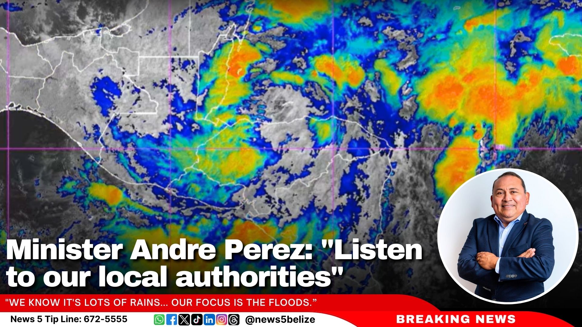
2025 started off with a bang—or rather, a splash! For Belizeans in the northeastern parts of the country, New Year’s Day was all about rain instead of fireworks, with rainfall totals reaching between five and seven inches. Chief Meteorologist Ronald Gordon explained that these showers are due to a lingering front over the region. When we asked Gordon about the upcoming weekend weather, he told us to expect more rain and cooler temperatures.


             Voice of: Ronald Gordon

Voice of: Ronald Gordon, Chief Meteorologist

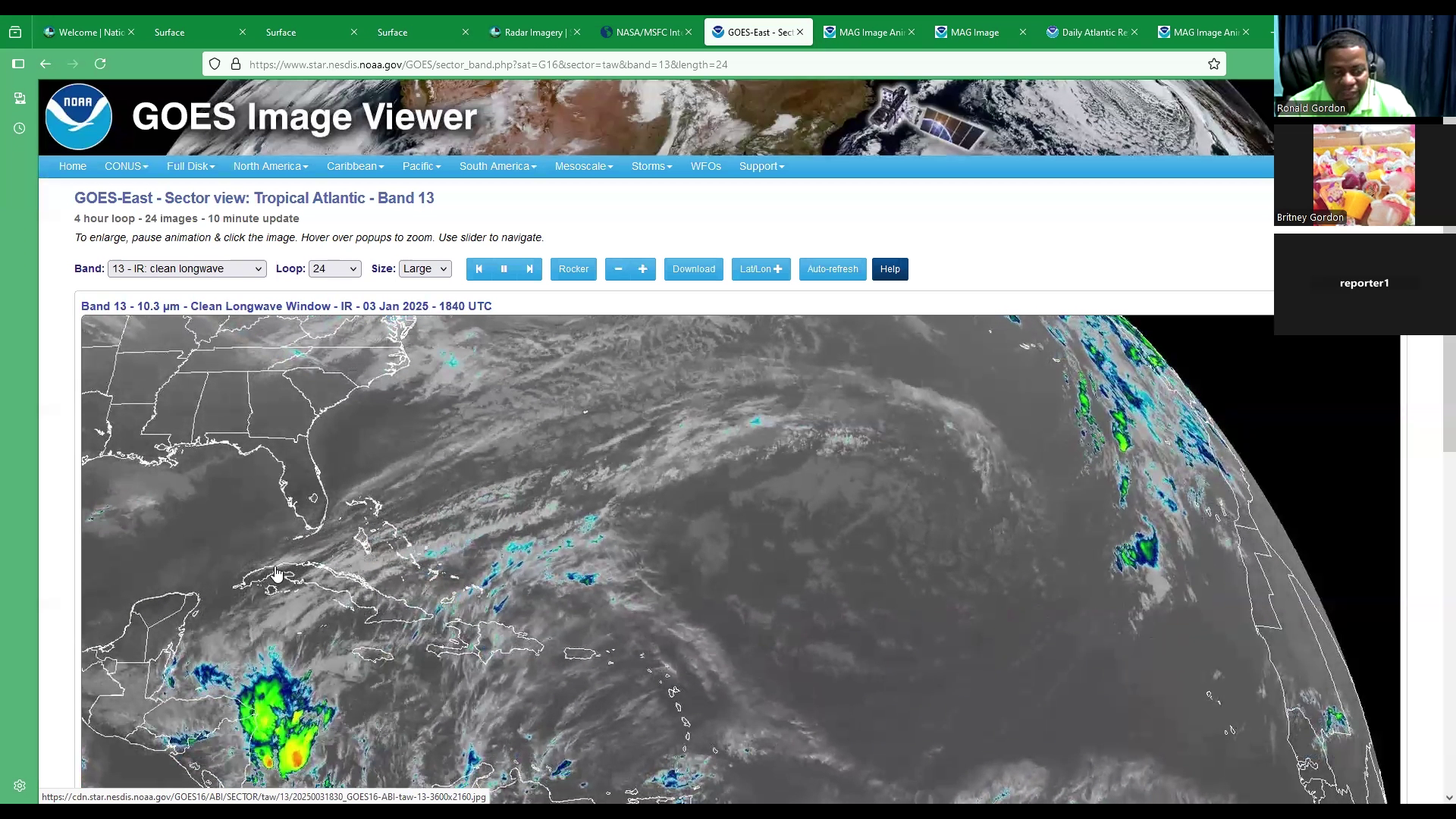
“We have a front which has been lingering just north of the country. this front is very weak and diffused. And at the moment, extending across the Bahamas, Cuba, into the northwestern Caribbean Sea, up to northern Belize at the moment.  Previously it was located over just the north of Yucatan and ahead of the front we have had a lot of prefrontal activity as we refer to it, and that is rainfall. This front is drifting very slowly to the south and will basically dissipate over the country over the weekend. However, it’ll continue, continue to produce some rainfall, which you will share now based on the forecast. So, I’m advancing the forecast frame up to this point, which shows the line of rain associated with the front, extending to Belize. And as we move into the weekend, farther, you will see that most of the activity will drift more to the south of the country. And that will persist throughout Saturday into Sunday, with most of the rainfall being recorded over the southern districts of Toledo and Stann Creek. However, we do expect that we still could expect some light rains over the other parts of the country, but not significant accumulations with this particular front as it dissipates. By Sunday, we should see better conditions as the front disappears even farther.  And then what you’re seeing here coming across the United States is another significant cold front. Extending into the northwestern Gulf of Mexico. As I advance the frame up to Monday, you can see the front. Now, this new front extends across the central Gulf of Mexico into the Bay of Campeche and later Monday night into Tuesday, you begin to see these greens again over Belize, And this is associated with prefrontal activity from this next front, which is approaching around the middle.  Or the early to the middle part of next week.”


2024 Hurricane Season Closes with Above-Average Activity

The 2024 Atlantic hurricane season officially concluded on November 30, surpassing historical averages in activity. This season recorded 18 named tropical systems, significantly higher than the annual average of 14. Of these, seven were tropical storms, and 11 developed into hurricanes, with a surge in activity after the typically peak month of September.

Belize was impacted by two tropical storms, Nadine and Sara.

The hurricanes this season were categorised as follows:

Category 5: Beryl and Milton

Category 4: Helene

Category 3: Kirk and Rafael

Categories 1 & 2: Debby, Ernesto, Francine, Isaac, Leslie, and Oscar

Meanwhile, tropical storms such as Alberto, Chris, Gordon, Joyce, Nadine, Paty, and Sara remained below hurricane strength.


Flood Alerts Issued for Belize’s Waterways

Residents in various regions are advised to monitor waterways and exercise caution due to fluctuating water levels.

In Region 7, the Rio Hondo at Blue Creek North, Santa Cruz, San Antonio, San Roman, and Douglas to the coast is experiencing decreasing flood stage levels. Meanwhile, the New River at Hill Bank, Tower Hill, and Caledonia to the coast is at bankfull stage levels.

In Region 9, extreme caution is urged as the Mopan River at Benque Viejo Town shows receding flood levels nearing Hurricane Mitch levels, with further decreases expected. The Macal River at Fortis facilities, including the Chalillo, Mollejon, and Vaca spillways, is actively spilling. At San Ignacio, flood levels are decreasing, while on the Belize River at More Tomorrow, flood levels are also dropping. However, at Double Run, increasing flood stage levels persist. In Crooked Tree Lagoon, water levels have surpassed the causeway and continue to rise.

In Region 11, decreasing flood stage levels are reported on the Sibun River at Freetown Sibun and the Southern Lagoon at Gales Point Village. Watersheds along the eastern slopes of the Maya Mountains and the Sittee River at Kendal Bridge are experiencing minimal decreases in flood levels. However, the branches of the Monkey River at Swasey and Bladen, the Deep River at Medina Bank, and the Rio Grande at San Pedro Columbia and Big Falls South are showing above-normal levels. The Moho River at Blue Creek South and Jordan and the Temash River at Crique Sarco are also reporting above-normal levels.

In Region 13, the Sarstoon River continues to exhibit above-normal levels.

Further updates will be provided as necessary. Residents are encouraged to remain vigilant and take all necessary precautions.

NEMO Deploys Teams to Assist Flood Victims

Villagers in Waist-deep Water in More Tomorrow

We’ve already shared how the villagers in Roaring Creek are coping with the floodwaters from Tropical Storm Sara. Meanwhile, residents on the other side of the creek in More Tomorrow Village are doing slightly better. Over the weekend, they were wading through waist-deep water, but it has since receded. However, one villager mentioned that they expect the water levels to rise again in the coming days.


            Terrence Sutherland

Terrence Sutherland, More Tomorrow Resident

“The rain that come the last couple of days mein. It really flood out this area from here gaan right down tha lone water you see and I went to the village this morning and mein it was so rough and I know the people down there tek a liking because of the rain, it was a lot of rain. Down that side it was pretty rough. Like I tell you in some of the house people still have water and some have more water like what I tell you the river is still coming down, so the river nuh reach yet down here.”


Britney Gordon

“How high would you say the water is”


Terrence Sutherland

“Well I would figure about 3 or 4 feet in those people house, and it will get more higher because like I tell you the water still the come down.”


Britney Gordon

“And you said it wasn’t too bad on your farm over here, but like what did you see?”


Terrence Sutherland

“Well when I come out from out of my house. I come out like two and a half feet out in my yard with water.”


Britney Gordon

“And you said you recently to more of the entrance, what was it like when you were living back there?”


Terrence Sutherland

“It was pretty rougher, just like what I tell you. The water reach way in the house. Like when I mih deh deh like a couple of five inches inside the house.”


Britney Gordon

Would you say that it has gotten worse over the years? Or has it been better? Is there anything to alleviate it?”


Terrence Sutherland

“Well I think with this flood weh the come right now it’s just like a hurricane flood. To me it get the same way or worse. It could be a little worse”


Britney Gordon

“How do you see the villagers coping with it.”


Terrence Sutherland

“Well. Like I tell you I mih live back there already more in the village before I move to my farm and we just have to cope with it. Like an animal on a little hill you know but all ah we just have to stay together.”


Britney Gordon

“So they just go through the water and go where they have to go?”


Terrence Sutherland

“Yeah, they have to come out and do a little shopping, and go back inside and just try to make life back again, but yesterday the little group mih come back here and pass and I think they gave them a little food. The food they gave them is not for no long while but for probably a couple days, about two three days and they wah need food again.”


Britney Gordon

“So how long do you think it will be until this water goes down, you said more is to come but how long does that usually last?”


Terrence Sutherland

“When that water left from San Ignacio, it take like two days and a half to reach down here and down here it will last another two and a half to three days down right in the village.”


All-Clear Issued as TS Sara Weakens

As of 12:00 PM on Sunday, November 17, 2024, Tropical Storm Sara has weakened into a tropical depression. The storm, now located about 55 miles west of Belize City, is moving west-northwest at 8 mph with maximum sustained winds of 35 mph. The tropical storm warning for Belize has been discontinued, and an All-Clear has been declared.

Despite the storm weakening, heavy rainfall continues to pose a flood risk. According to the National Emergency Management Organisation’s (NEMO) latest advisory, Belize has already recorded up to 18 inches of rain in some areas, with another 1-2 inches expected by evening. Flood warnings remain in effect, particularly for low-lying areas, and significant flooding is possible, especially in Cayo and Belize Districts.

Local roads are affected by flooding, with some routes only passable by large vehicles. Several bridges, including the Salvador Fernandez Bridge in Bullet Tree, are closed due to rising water. The Transport Department will provide an update on bus services later today.

The National Emergency Management Organization (NEMO) advises continued caution, particularly in flood-prone areas. Shelters remain open, and residents are urged to monitor conditions and follow emergency plans. The Philip Goldson International Airport is expected to resume operations on Monday, November 18.

NEMO: “Businesses in Stann Creek District Ordered to Close by 6 PM Today”

Tropical Storm Sara continues moving closer to Belize, with the latest update at 3:00 PM showing the storm just 110 miles southeast of Belize City. NEMO reinforces its tropical storm warning for the entire Belize coastline, including the cayes. Businesses in the Stann Creek District are ordered to close by 6 PM today, and all sectors—agriculture, tourism, and fisheries—are urged to implement their emergency plans. “Businesses in the Stann Creek District are to close at 6 p.m. today and remain closed until the ALL CLEAR is issued,” the advisory notes.

“The main threat to Belize from Sara continues to be heavy rainfall,” NEMO warned, with some areas already seeing up to 15 inches of rain. An additional 2 to 6 inches is expected through Sunday evening, which could cause severe flooding, especially in the Rio Hondo, Macal, Mopan, and Belize Rivers. A small craft warning continues to be in effect due to rough seas.

TS Sara’s winds are currently at 45 mph, and although no major strengthening is expected, winds could reach 50 mph as the storm nears. NEMO has activated Phase 3—Red Two—of the National Hurricane Plan, meaning landfall is expected within 36 hours.

“Persons living in areas under Flood Warning MUST remain vigilant and be prepared to implement emergency plans if necessary,” NEMO advised. Shelters will open if needed, and the public will be updated through district coordinators.

The Philip Goldson International Airport ceased operations at 3:15 PM today, and bus services are running based on road conditions.


Chief Met: “Over 15 Inches of Rain Seen in Some Stations”


TS Sara Moves Toward Belize, Flood Warnings Issued

Belize remains on high alert as Tropical Storm Sara continues to move toward the country. The National Emergency Management Organization (NEMO) said in its latest advisory that the nation remains in Phase 3—Red Two of the National Hurricane Plan, signalling that landfall is expected within the next 36 hours.

As of 12:00 PM today, Tropical Storm Sara was located about 125 miles southeast of Belize City, with maximum winds of 45 mph. NEMO reports that the storm is expected to approach the coast tonight and could make landfall by Sunday.

The biggest concern with Tropical Storm Sara is heavy rainfall. Since Thursday, some areas have already received over 15 inches of rain, and many other areas have seen 4 to 8 inches. NEMO warns that an additional 3 to 8 inches of rain could cause “significant and life-threatening flooding.”

The Central and Northern parts of Belize, including the Rio Hondo, Macal, Mopan, and Belize Rivers, are under Flood Warnings.

NEMO is advising all Belizeans, especially those in flood-prone areas, to start their emergency plans now. Residents should “remain vigilant” and be ready to shelter in place or evacuate if necessary. The agricultural and tourism industries are also being warned to take precautions, as strong winds and flooding could affect them.

Authorities urge the public to stay informed through official channels and to call NEMO’s hotline at 936 for help.

Chief Met: “Over 15 Inches of Rain Seen in Some Stations”

The National Meteorological Service (NMS) has issued weather alerts due to Tropical Storm Sarah, which is expected to make landfall on Sunday. In a briefing this morning, Chief Meteorologist Ronald Gordon explained that the storm is located about 140 miles southeast of Belize City, moving west-northwest at a slow pace with maximum winds of 45 miles per hour.

A Tropical Storm Warning is now in effect for the entire Belize coastline and offshore areas. A Small Craft Warning has also been issued since yesterday and remains in effect, advising boat operators to stay in safe harbor. The weather will remain stormy today and tomorrow, with “squally and gusty winds and continued rainfall,” Gordon said.

Heavy rainfall has already been reported across the country, with one station recording over 15 inches of rain. Some areas have seen almost 4 inches in the past 12–18 hours.

“We expect conditions to remain cloudy tomorrow with showers persisting and decreasing later in the afternoon, afternoon into the night. By Monday, we expect fair conditions,” Gordon said, adding that the weather should improve just in time for the 19th of November celebrations.

Gordon said that the storm’s disorganised structure suggests that most of the heavy weather is occurring well ahead of its center. “A lot of the activity is occurring away from the centre,” he explained. This means that once the storm makes landfall tomorrow, conditions may improve quickly.

Minister Andre Perez: “Listen to our local authorities” 

Minister of Blue Economy and Civil Aviation, Andre Perez, gave an update on the preparations and response to Tropical Storm Sarah, especially in the cayes. During a briefing this morning with the National Meteorological Service (NMS) and the National Emergency Management Organization (NEMO), he reminded the public to focus on safety as heavy rain and flooding continue.

Minister Perez stressed the importance of staying informed through official sources. “I want to caution everyone to listen to our local authorities,” he said, adding that while social media can be helpful, the most accurate information comes from trusted authorities.

He confirmed that parts of Caye Caulker and San Pedro are experiencing heavy rainfall. “While we are anchoring down, we know it’s lots of rains… our focus is the floods,” the minister said.

Evacuation efforts are underway in the affected areas, and shelters have been opened in both Caye Caulker and San Pedro.

For more information, people can contact NEMO coordinators for the cayes. In Caye Caulker, the coordinator is Kristylane Wolfe at 611-6603. In San Pedro, Vanessa Parham can be reached at 614-5865 or 226-4821/4824/4358.


PGIA Closes as TS Sara Approaches 

PGIA Closes as TS Sara Approaches 

The Philip S.W. Goldson International Airport (PGIA) has announced it will close operations this afternoon due to worsening weather conditions from Tropical Storm Sara.

Flights already in the air will arrive as scheduled. Travellers are advised to check the airport’s website and social media for real-time updates.

“Your safety remains our utmost priority, and we appreciate your understanding,” said the airport in its update.

Exit mobile version