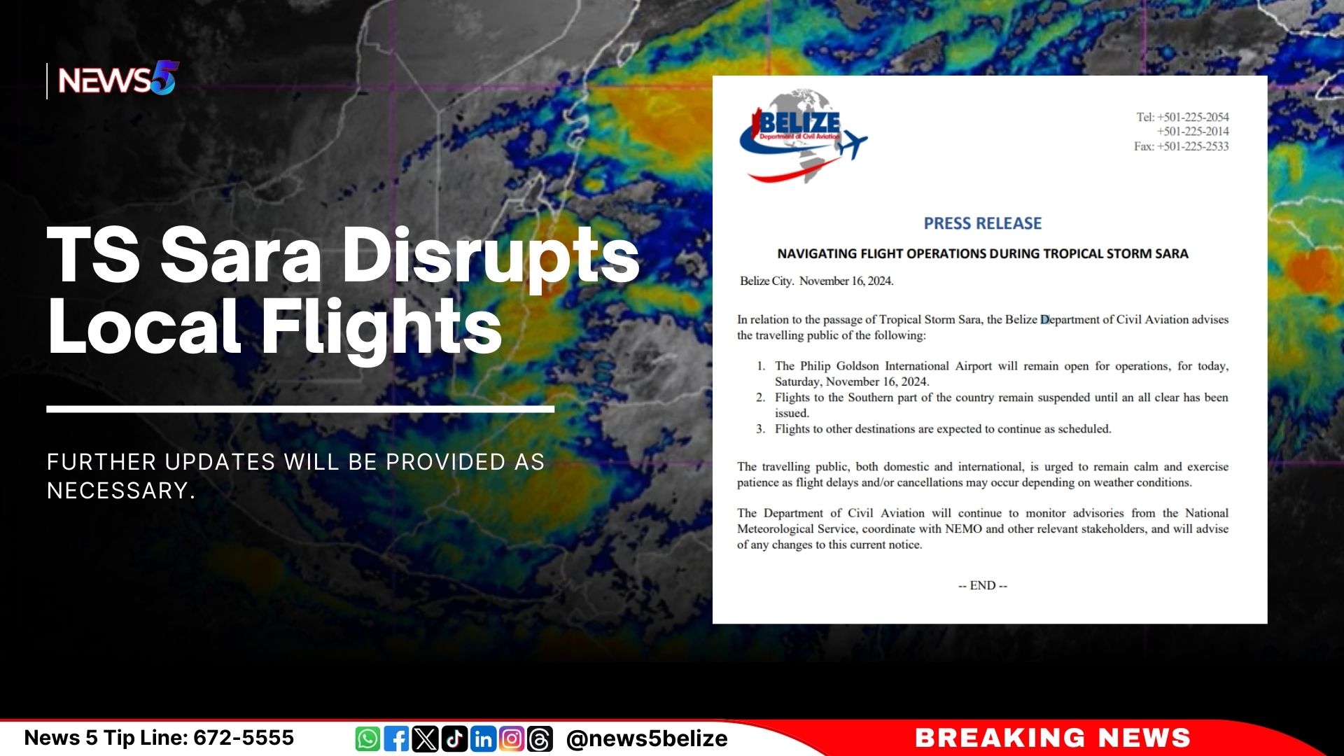
The Belize Department of Civil Aviation has issued an update regarding Tropical Storm Sara and its impacts on flight operations. As reported, the Philip Goldson International Airport will remain open for operations today, Saturday, November 16.
However, flights to the southern part of the country have been suspended “until an all-clear has been issued.” Flights to other destinations are expected to continue as scheduled, though delays and cancellations are possible depending on weather conditions.
The Department urges domestic and international travellers to “remain calm and exercise patience” during this time. The Department is closely monitoring the situation in collaboration with the National Meteorological Service (NMS) and the National Emergency Management Organization (NEMO).
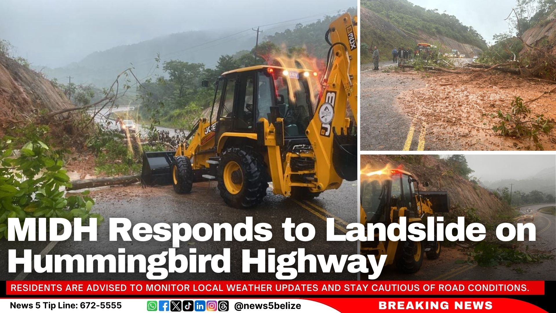
The Ministry of Infrastructure Development and Housing (MIDH) has deployed personnel and equipment to clear a landslide at Mile 29 on the Hummingbird Highway. Motorists are urged to drive carefully and be considerate of the team working to resolve the situation. This comes as rain is experienced across the country as Tropical Storm Sara makes its way towards Belize.
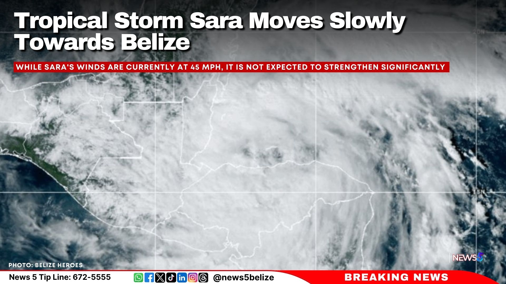
A tropical storm warning is still in effect for the entire coast, including the Cayes. According to the latest updates issued this morning at 9 AM, the storm was located about 140 miles southeast of Belize City, with sustained winds of 45 mph. The storm is expected to make landfall in Belize on Sunday.
Residents are advised to monitor local weather updates and stay cautious of road conditions.
As of 9:00 AM, Tropical Storm Sara remains a threat to Belize, with a warning still in effect for the entire coastline, including all cayes. According to the latest updates, Sara was about 140 miles southeast of Belize City, moving slowly towards the country at just 2 mph. The storm is expected to make landfall in Belize by Sunday.
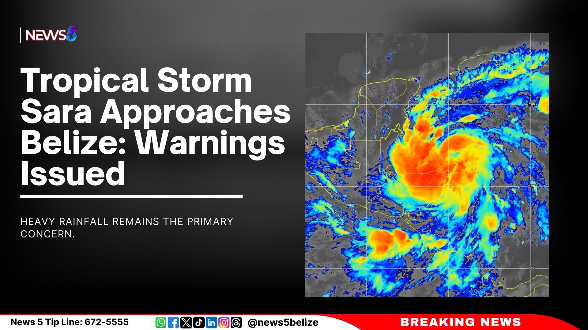
While Sara’s winds are currently at 45 mph, it is not expected to strengthen significantly. However, gusty winds could reach up to 50 mph as it approaches. The main concern for Belize is heavy rainfall, with some areas already seeing over 15 inches of rain, leading to flooding. An additional 3 to 8 inches of rain is expected through Sunday.
Strong winds and rough seas are also affecting the country, with gusts of up to 39 mph recorded. A small craft warning is in place, urging boaters to stay in safe harbors. The storm could cause some minor damage to weaker structures due to the winds.
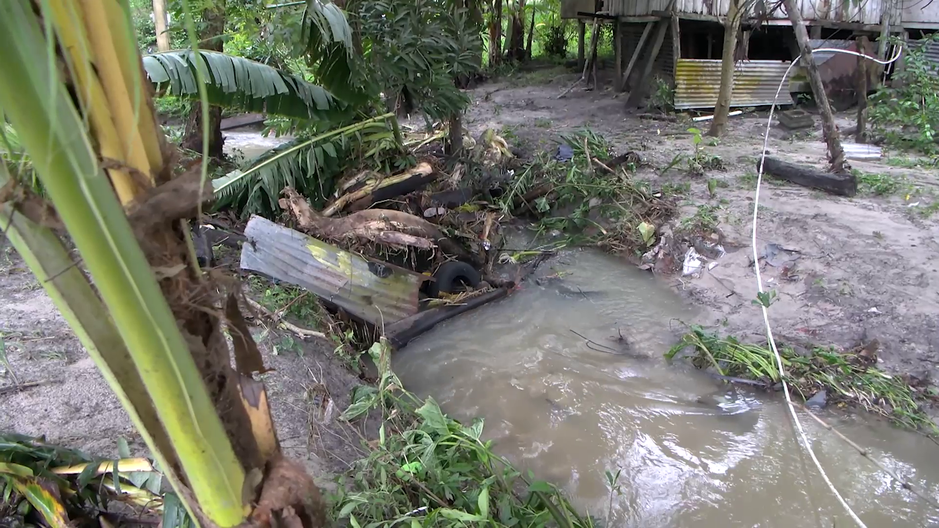
Tropical Storm Sara is set to hit Belize earlier than expected. Initially, it was predicted to make landfall around midday Sunday, but now it’s forecasted to arrive early Sunday morning. We’ll share more about the preparations and what residents, especially in southern Belize, can expect. But first, let’s head out west. On Thursday evening, the outer bands of Tropical Storm Sara brought the heaviest rainfall yet to the Santiago Juan Area in San Ignacio Town. This caused flash flooding, with the creek rising to levels residents say they’ve never seen before. Thankfully, no lives were lost, but many in the community reported damage to household items and pipelines. News Five’s Paul Lopez traveled west and filed this report.
Paul Lopez, Reporting
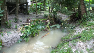
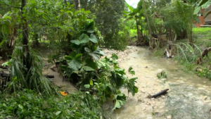
A western community is grappling with the aftermath of a flash flood that swept through properties and homes. On Thursday evening, floodwaters surged through the Santiago Juan community, off Bullet Tree Road in San Ignacio Town, reaching unprecedented levels. Video footage shows streets turning into rivers as the floodwaters rushed downhill. Today, a creek in the area stands as a stark reminder of the massive volume of water that came with the flash flood.
Voice of: Gian Rodriquez
Voice of: Gian Rodriquez, Santiago Juan Resident
“Ih mih the rain fih probably about three to four hours and I see it was nearly across the road deh.”
Paul Lopez
“For you is this something you have seen happen before?”
Voice of Gian Rodriquez
“Well, no, not really, I have never seen it reach so high yet.”
According to Chief Meteorologist Ronald Gordon, the area received the largest volume of rainfall in the country associated with Tropical Storm Sara.
Ronald Gordon
Ronald Gordon, Chief Meteorologist
“The western part of the country where the flooding was reported last night received the highest accumulation with rainfalls totaling up to about four inches. Bullett Tree recorded about ninety-four millimeter. Ninety-six point six in Santa Elena. Most of this occurred during the heavy rainfall resulting in flash flooding in those areas.”
Neiby Morales was unable to save any of her household items, as the flood waters came rushing down the creek next to her home. She sought refuge inside an abandoned, elevated, wooden structure in front of her house. She recounted the frightening ordeal when the flash flood took her washing machine downstream.
Voice of: Neiby Morales
Voice of: Neiby Morales, Santiago Juan Resident
“I didn’t expect the water was going to rise up to where it rise up yesterday. It took me to rush, to run.”
Paul Lopez
“Is it the first time it has risen so high?”
Voice of: Neiby Morales
“It is the first time. I didn’t expect to rise up to the step. It was so scary. I was by myself here yesterday. I was so scared I can tell you. I am in this one from the front, because it all wet and the things from inside, everything. Bed and the sofa and everything. How I can’t back it and it is to heavy for me to back it. It had to stay right there.”
Chief Hydrologist Tenielle Hendy explains what led to the flash flood.
Tenielle Hendy
Tenielle Hendy, Chief Hydrologist
“What we determined happened is that recall earlier this week there was about fourteen inches of rain that were received in the Maya Mountains in two different spirts. That was received overnight. Then we received additional rain yesterday and this morning. So, what you are seeing is an accumulation of these flood waters making their way down these streams. They will not all come down at once. They will come down in waves according to bankfull stage. Bank full means that the river cannot take anymore and when it cannot take anymore, it will flow overland or travel rapidly down the system.”
Thankfully, no lives were lost in Thursday evening’s flash flood. Today, residents were busy preparing for the upcoming rains as Tropical Storm Sara is expected to make landfall south of Belize on Sunday. Despite the forecasted landfall, the rain is expected to continue over the next several days.
Ronald Gordon
“In terms of rainfall forecast… forecasted from six this moring until six on Sunday, indicating that we can expect at least ten inches more of rainfall, mostly over the south according to this model from the system. Again, it is just a model. We saw what occurred in San Ignacio, Santa Elena where we had significant rainfall.”
The National Emergency Management Organization says it has deployed a team into the affected areas in the Cayo district to assess damages.
Paul Lopez
“What are the concerns for you all any at all given that the rains will continue?
Voice of: Gian Rodriquez
“From what I mih hear a hurricane mih the come. But that is until Sunday they say. So, if this done the do that, I don’t know what that could bring.”
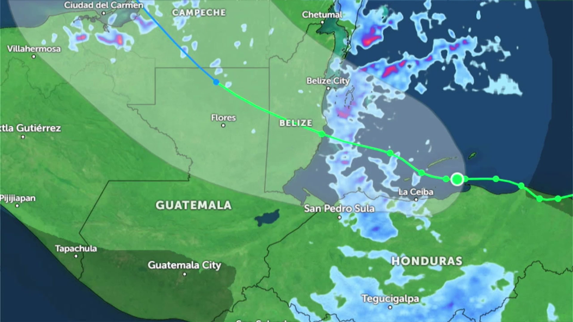
As we mentioned, the latest forecast models show Tropical Storm Sara making landfall in southern Belize with winds up to sixty miles per hour. As of two PM today, the storm was located about a hundred miles southeast of Belize, moving west at a slow pace of two miles per hour. This sluggish movement has caused the heavy rainfall we’ve seen over the past twenty-four hours, and much more rain is expected over the next two days. Chief Meteorologist Ronald Gordon has more details for us.
Ronald Gordon
Ronald Gordon, Chief Meteorologist
“Showing that it covers from southern Belize to almost the full north of the country. So, there is still some uncertainty as to where the system will track. But the most probable track which is at the center of the cone is that the system goes and makes landfall somewhere between Dangriga and Placencia based on this current forecast. So, for tomorrow morning, according to the GFS model, the low will remain where it is but we will continue to have bands coming across Belize. Then if I advance the frame twenty-four hours later, which is six a.m. on Sunday morning, you can see the low pressure now along the coast of Belize. One of our stations in the Cayes recorded about thirty-two to thirty-five knots, which is almost at the lower threshold of tropical storm force winds and that is why the country is currently under a tropical storm warning, because we expect to have possible gust and sustained winds of tropical storm force in the outer bands, associated with tropical storm Sara. Again indicating that early Sunday morning we could have potential landfall between Dangriga and Placencia with sixty-mile per hour winds. It will be moving west northwest at sixty miles per hour; therefore it should be crossing the country in about six hours or so, and by six in the evening the system is expected to be well to the west of us over Guatemala.”
All this rain has significantly increased soil moisture levels. However, Chief Hydrologist Tenielle Hendy reassures us that there is no imminent flash flood threat now. Here’s what she shared with reporters this afternoon.
Tenielle Hendy, Chief Hydrologist, N.H.S
“As you can see the soil moisture is very high and saturated in this central region of the country. We do not have any imminent flashflood threats in any of our model time series, which is one three and six hours, same is for the persistent time flood threat for our flash flood guidance. Of note we are seeing positive indication for landslides in the country. You can see it here for Honduras. But, for Belize we just have some areas in the north that we will need to monitor for our landslides.”
Paul Lopez
“I think yesterday we received information that there weren’t going to be any indi9cation of flash flood, yet what we saw in San Ignacio, in the Bullet Tree Area were flash floods.”
Tenielle Hendy
“What happened is that the platform we are running is that it has size limitation, not only for Belize but for the entire Central American region. And the issue is that some of these mini water shed sizes are computationally too large for these systems to address and we do find other ways of indicating whether that system will be flooded. Which is why we had put out the flood warning for the Mopan River and the Macal, including the Belize River system in this area. We don’t want the public to misunderstand that flood warnings are just for riverine flooding or rainfall associated flooding. Flooding is flooding. It doesn’t matter what area or component of flooding we are speaking about. So flash flooding is included in that flood warning.”
Tropic Air has announced that all flights after four PM today are canceled due to bad weather. However, the Philip Goldson International Airport will continue to operate as usual. Event planners are being asked to postpone their events. Businesses are advised to ensure their employees’ safety. National Emergency Coordinator at NEMO, Daniel Mendez, assures that organizations are ready to respond to any requests for assistance.
Daniel Mendez
Daniel Mendez, National Emergency Coordinator, NEMO
“What we have been doing is to ensure that all of our emergency operation centers across the country remain on standby. All our district coordinators are on duty and ready to respond to requests for assistance that may arrive at our offices. All of our national committees have met, and they are prepared to implement operational plans as necessary. For us here at the NEMO secretariat we continue to monitor in collaboration with the hydrology and meteorology department and we are prepared to support response as required. We are anticipating high rainfall and strong winds and we are preparing for potential flooding in parts of the country. Points to note, as we have indicated, all interest, especially those in southern Belize must pay close attentional to this system and need to prepare their emergency plans now. Persons living in areas under flood warning must remain vigilant and be prepared to implement emergency plans as necessary. We are asking the organizers of public events are advised to postpone their events until the all clear is given in the interest of public safety. We are also asking business owners to update their business continuity plans and be prepared to implement that. Business owners in affected areas are also asked to ensure the safety of their employees. Also, considering the road conditions are very slippery, we are asking motorist to drive with extreme care to avoid accidents. We have received information that the PGIA will continue to function today as normal. Operations on Saturday may be impacted so passengers are asked to expect delays. This will be reviewed tomorrow and updated as necessary. So please look out for a statement from the Department of Civil Aviation. Also, water taxis will continue to operate today. Operations will close at midday tomorrow.”
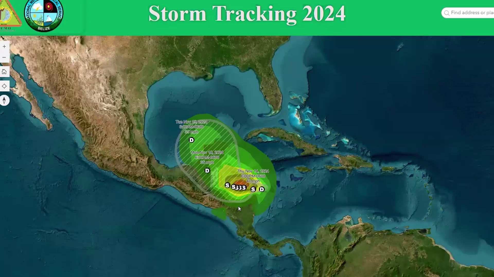
As of 9:00 AM today, Tropical Storm Sara continues its slow approach toward Belize, prompting a tropical storm warning from Belize City southward to the Guatemala border, including offshore cayes. The National Emergency Management Organization (NEMO) has declared Phase 3 – Red Two of the National Hurricane Plan, signalling that landfall is expected within 36 hours.
Sara was located approximately 175 miles east-southeast of Belize City, moving west at 7 mph with sustained winds of 50 mph. Forecasts predict Sara could strengthen, reaching 60 to 70 mph winds at landfall, expected early Sunday near southern Belize.
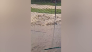
Heavy rainfall remains the primary concern. Totals of 5 to 10 inches, with isolated higher amounts, are forecast through Sunday, exacerbating flooding in several areas, particularly in the Central and Northern Regions. Flood warnings are in effect for the Rio Hondo, Macal, Mopan, and Belize Rivers. Flooded roads, including the San Roman and San Antonio Roads in the Orange Walk District, have been reported.
Winds of 60 to 70 mph may cause damage to structures, trees, and crops. A storm surge of 1 to 3 feet is possible near areas of onshore flow. Rough seas and strong gusts have prompted a small craft warning; mariners are advised to remain in safe harbour.
Residents in the warning area are urged to implement emergency plans, stock up on essential supplies, and remain vigilant. Shelters will be opened if necessary. Motorists should drive cautiously due to slippery roads, and businesses are advised to finalise continuity plans.
The tourism, agriculture, and fisheries sectors are also advised to monitor the situation and prepare emergency measures. Public events should be postponed until the all-clear is given.
The public is encouraged to follow official updates from NEMO and the National Meteorological Service. NEMO’s hotline is 936 for further assistance. Stay informed and prepared as Belize braces for Tropical Storm Sara.
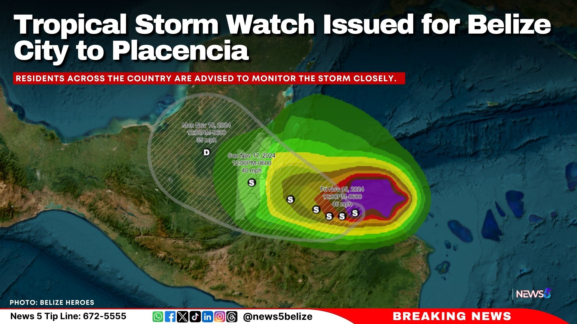
A Tropical Storm Watch is now in effect from Belize City southward to Placencia as Tropical Storm Sara moves closer to the country.
At 6:00 a.m. local time, Sara was located near latitude 16.1N, longitude 85.5W, about 205 miles east-southeast of Belize City. The storm is moving west at 9 mph, with sustained winds of 50 mph. Sara is expected to slow down and shift slightly to a west-northwest track by late Saturday.
The storm’s center is forecast to pass near the northern coast of Honduras today and approach Belize’s coast by Sunday. Some strengthening is possible before landfall, with maximum sustained winds of 50 mph anticipated.
While the Tropical Storm Watch applies to areas from Belize City to Placencia, residents across the country are advised to monitor the storm closely.
– Rainfall: Forecasts predict 5 to 10 inches, with locally higher totals, posing a significant risk of flooding.
– Winds: Gusts of 50 to 60 mph could cause damage to trees, crops, and weak structures.
– Coastal Flooding: Minor flooding is expected in areas north of the storm’s center.
– Marine Conditions: A small craft warning remains in effect due to rough seas and strong winds near thunderstorms.
Flood warnings are active for the Central and Northern regions, including the Rio Hondo, Macal, Mopan, and Belize Rivers. Several roads, including San Roman and San Antonio in the Orange Walk District, remain submerged.
The National Emergency Management Organization (NEMO) has issued the following advisories:
– Residents in flood-prone areas should clear drains and prepare to evacuate if necessary.
– Ensure emergency kits are stocked with food, water, and medications.
– Motorists should drive cautiously due to slippery road conditions.
– Tourism, agriculture, and fisheries sectors are urged to activate emergency plans.
Shelters will be opened in affected areas if required, and NEMO’s hotline (936) is available for assistance.
NEMO and the Belize Met Service continue to monitor Tropical Storm Sara, with updates expected throughout the day. Residents are reminded that hurricane season remains active, and preparedness is key to ensuring safety.
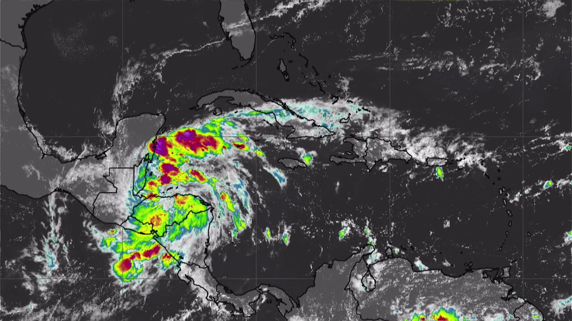
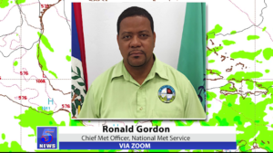
This afternoon, Tropical Storm Sara formed off the coast of Honduras and Nicaragua. According to the National Emergency Management Organization’s three p.m. advisory, Sara was located three hundred and thirty miles east-southeast of Belize City, moving west at ten miles per hour. The storm is expected to continue its westward path at a slower pace over the next two days. Earlier today, during a NEMO press conference, Sara was projected to make landfall north of Belize, which was the center of the cone of probability at that time. However, this afternoon’s update shows the center of the cone has shifted further south, closer to Placencia. This change highlights the inherent uncertainty in these projections. Here’s what Chief Meteorologist Ronald Gordon had to say this morning.
Via Zoom: Ronald Gordon
Via Zoom: Ronald Gordon, Chief Meteorologist
“This is the global forecast system, better known as the American model. Initialized at midnight local time, and let us move forward int time. You can see the low pressure center around here as we have indicated near the north east coast of Honduras and Nicaragua. If we forward in time and go six a.m. tomorrow, you see the low here, north of Honduras. Let us move forward another twenty-four hours, you have the low remaining there but becoming much more disorganized. This is because of land interaction. Because the system is moving so close to Honduras this model is suggesting that is going to weaken. These lines are called isobars or lines of equal pressure. The closer you see these together the stronger the system. What you have noticed in the last twenty-four hours, these lines have moved further apart indicating that the system is weakening because of land interaction. Interestingly I want you to focus on Belize, you can see that even though it is a weaker system, there are bands of thunderstorms affecting the country. These colors of deep blue towards purple are indicating heavy rainfall activity in southern Belize. Let me advance to twenty-four hours. This will be Sunday morning, centered roughly here off the coast of Belize, rainfall again impacting the country. I move forward again and you can see the low impacting the land and moving across the land. The rains decreasing thereafter. This is one interpretation. One model’s idea of what could happen. Models are not gospel truth. They have inaccuracies. They have assumptions. So it is important we use these with caution.”