


Tropical Storm Beryl Set to Become Major Hurricane by Monday
Tropical Storm Beryl formed Friday evening in the Atlantic, east of the Windward Islands, and is projected to become a “dangerous major” hurricane by Monday, according to the National Hurricane Center.
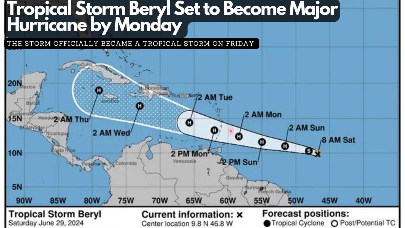
As the second named storm of the 2024 Atlantic hurricane season, Beryl is anticipated to reach hurricane status by Saturday night or Sunday morning as it moves westward. The storm officially became a tropical storm on Friday, approximately 1,100 miles southeast of the Windward Islands at the eastern end of the Caribbean.
As of the hurricane center’s 11 a.m. advisory on Saturday, Beryl was moving at about 23 mph, with maximum sustained winds of 65 mph. The center predicts that Beryl will strengthen into a hurricane by late Saturday or early Sunday and continue to intensify, reaching major hurricane status with winds of 111 mph or more before its center reaches the Windward Islands on Monday morning. The atmosphere and ocean conditions along Beryl’s path are described as “abnormally favorable for strengthening.”

However, conditions may become less favorable after the storm enters the Caribbean, where it could encounter disruptive winds that might prevent further strengthening, the center noted this morning.

Tropical Storm Beryl on NOAA Satellite on Saturday morning.
Beryl is currently 820 miles east-southeast of Barbados, and tropical storm-force winds are expected to extend 45 miles outward from the center. The storm could bring heavy rain, hurricane-force winds, and dangerous storm surges and waves as it crosses the Windward Islands on Sunday night into Monday. A hurricane watch has been issued for Barbados, and more watches are expected later Saturday as the system moves further into the Lesser Antilles, which include the Windward Islands, Leeward Islands, and Leeward Antilles.
Barbados and nearby islands could receive 3 to 6 inches of rain, with localized flooding in vulnerable areas and life-threatening surf and rip currents. People in the central and western Caribbean should monitor the storm’s progress, keeping in mind that the forecast’s margin of error can be significant four or five days out.
By Sunday evening, as Beryl moves into the Caribbean Sea, it could have winds up to 105 mph. Although atmospheric conditions in June are typically not conducive to storm strengthening, some computer models are “quite aggressive” and suggest that Beryl could be a major hurricane before reaching the Windward Islands. Once the storm enters the Caribbean, forecast models are not yet in agreement on its potential path. For now, the official forecast cone shows that the hurricane’s center could be near or over the western half of the Dominican Republic and Haiti on Tuesday evening and over Jamaica or eastern Cuba on Wednesday evening.
Facebook Comments