


Historic Hurricane Beryl Poses Threat to Belize
Tonight, Hurricane Beryl is barreling its way towards Central America. The tropical system developed into a hurricane over the weekend and rapidly intensified to a category four hurricane before making landfall in the eastern Caribbean. This is a historic tropical system as it is the first time a category four hurricane has developed within the Atlantic basin in the month of June. These types of weather systems are more common in the peak of the hurricane season, between August and October. Its projected path shows Belize and the Yucatan Peninsula inside the cone of impact. But it is too early for the experts to say whether Belize will experience a direct hit. Belize will however begin to experience the effects of the system as early as Thursday evening. Today, the National Emergency Management Organization hosted the first of a series of daily press conferences for this week. News Five’s Paul Lopez reports.


Ronald Gordon
Ronald Gordon, Chief Met Officer
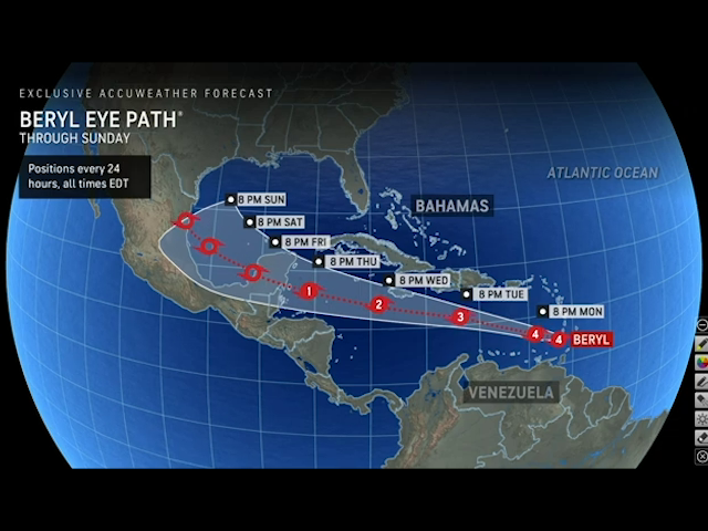
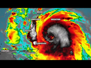
“Our update as of midday on a potentially catastrophic major hurricane Beryl was that it was moving west northwest at about twenty miles per hour away from Windward Island after having affected those island this morning. the projected forecast is for it to move to a west, northwest track towards the southeastern Caribbean Sea for the remainder of today, Tuesday, enter the central Caribbean Sea just around Jamaica on Wednesday and move into the northern Caribbean Sea on Thursday.”
Paul Lopez, Reporting
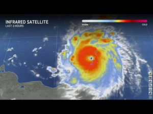
Beryl maintained its strength as a category four hurricane throughout the course of today, with wind speeds of up to one hundred and fifty miles per hour. Forecasts are calling for it to weaken as it enters the central Caribbean Sea.
 Ronald Gordon
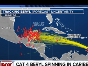
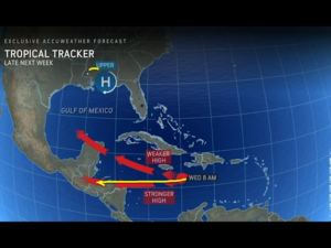
“In terms of the projected path, the system currently is moving west northwest. It will encounter a high-pressure ridge that will develop over the Gulf of Mexico forcing a more westward track. Just to make it simple for the public, a ridge is like a mountain, the hurricane cannot move over a mountain, so it moves around it. That ridge will block the system from moving north and push it on a westerly track after it leaves near Jamaica. There is still a lot of uncertainty. This is a four-to-five-day prediction. That carries a lot of uncertainty as you can see from the projected cone there is a hashed area near Belize indicating there is a high level of uncertainty where the system will be. However, the projected cone shows it anywhere from the southern district, let’s say Stann Creek to the Yucatan Peninsula.”
According to Gordon, the center of the hurricane can make landfall anywhere within the projected cone by Friday morning. There is also a great deal of uncertainty surrounding the strength that Hurricane Beryl will have when it makes landfall in the western Caribbean.
 Ronald Gordon
“In terms of possible impacts we cannot say precisely at the moment given the uncertainty. But if the system moves within the projected path, we will likely receive some impact including strong winds and heavy rainfall which we will be able fine tune as the weeks goes on as we get more information.”
The National Emergency Management Organization will be activated as of nine a.m. on Tuesday morning. Daniel Mendez, the National Emergency Coordinator, is advising the country to prepare for the arrival of Hurricane Beryl on Friday.

Daniel Mendez
Daniel Mendez, National Emergency Coordinator, NEMO
“We continue to encourage the public to prepare. We highly encourage people who are living in low lying areas or areas that are flood prone to consider early evacuation to start moving in an advance as this develops. As the chief meteorologist has said, there is a large area of uncertainty, but we cannot wait until it is too late, so we encourage you to get these things done as soon as possible.”
 The forecast track has shifted several times over the past twenty-four hours. According to Chief Meteorologist Ronald Gordon, it was moving further north from Belize. It then shifted south to include Belize. This is the uncertainty of the models that the experts are currently working with. One thing is certain, sea temperatures are above average for this time of the year. That is fuel for a tropical system.
Ronald Gordon
“The entire Atlantic and Caribbean basin are supercharged with hot water. So, we have looked at the figures. We are about two or three degrees Celsius above normal in terms of temperature. And like you said that is the energy these system needs to fuel them. That is precisely why this system intensified rapidly. This hurricane is the first category four hurricanes in history in recorded history for the month of June.”
 Daniel Mendez
“Our message has been since June, May, you need to have a plan, start preparing and so while we cant tell you to go out an purchase, what we can tell you is to ensure you have a plan, you know where to go. Again, with this great degree of uncertainty for us to say yes you need to purchase these things and stock up, I think it would be too early to say. You must know what to do and where to, and you cannot wait until the last minute.”
So, when will the experts be able to confirm whether this system will make direct landfall on Belize? Gordon projects that by Tuesday afternoon there will be greater certainty about the path of the hurricane.
Daniel Mendez
“The best-case scenario is that it goes through the Yucatan channel and doesn’t affect anybody. That would be the best case. The worst case is that it comes direct to the country as a category two or three hurricane and that would be the worst-case scenario.”
Reporting for News Five, I am Paul Lopez.
Facebook Comments