Should You Work as TS Nadine Approaches? 

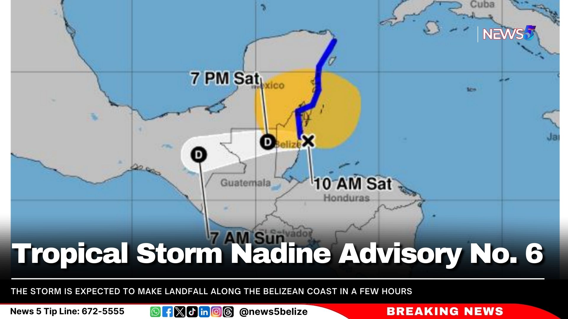
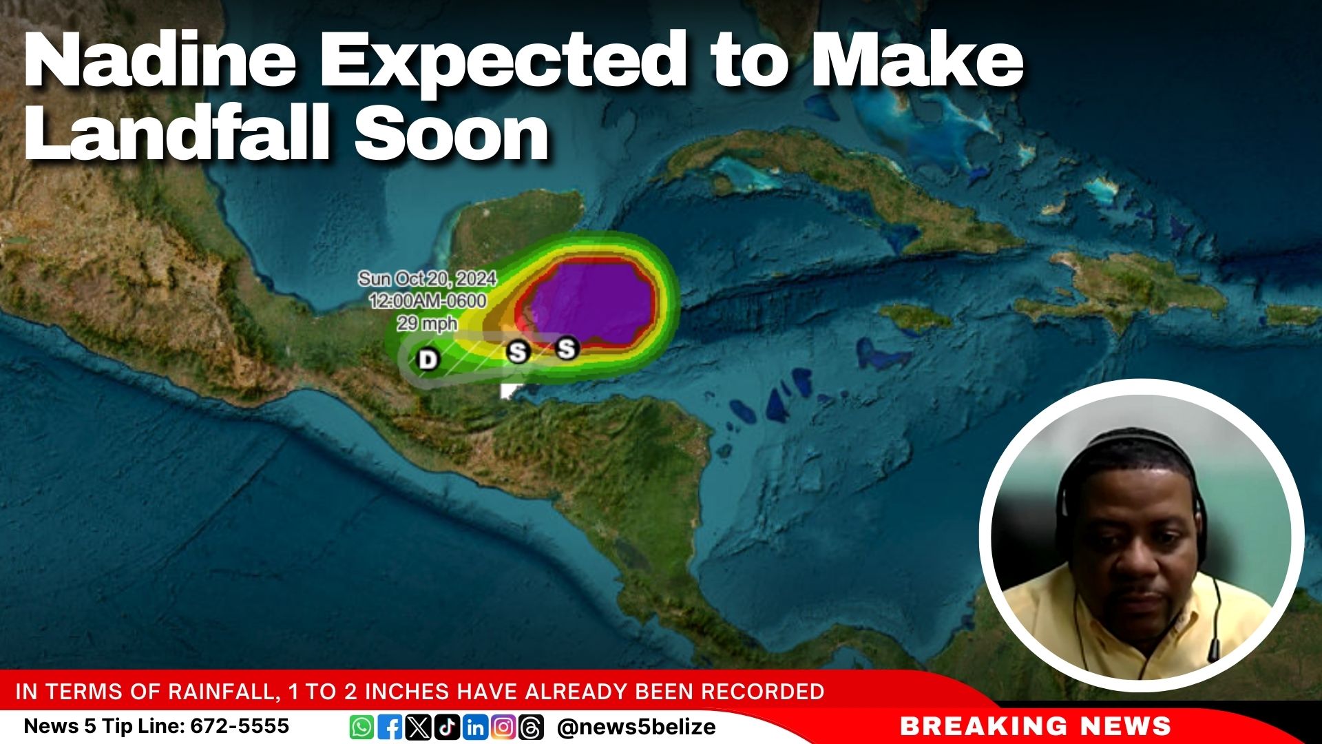
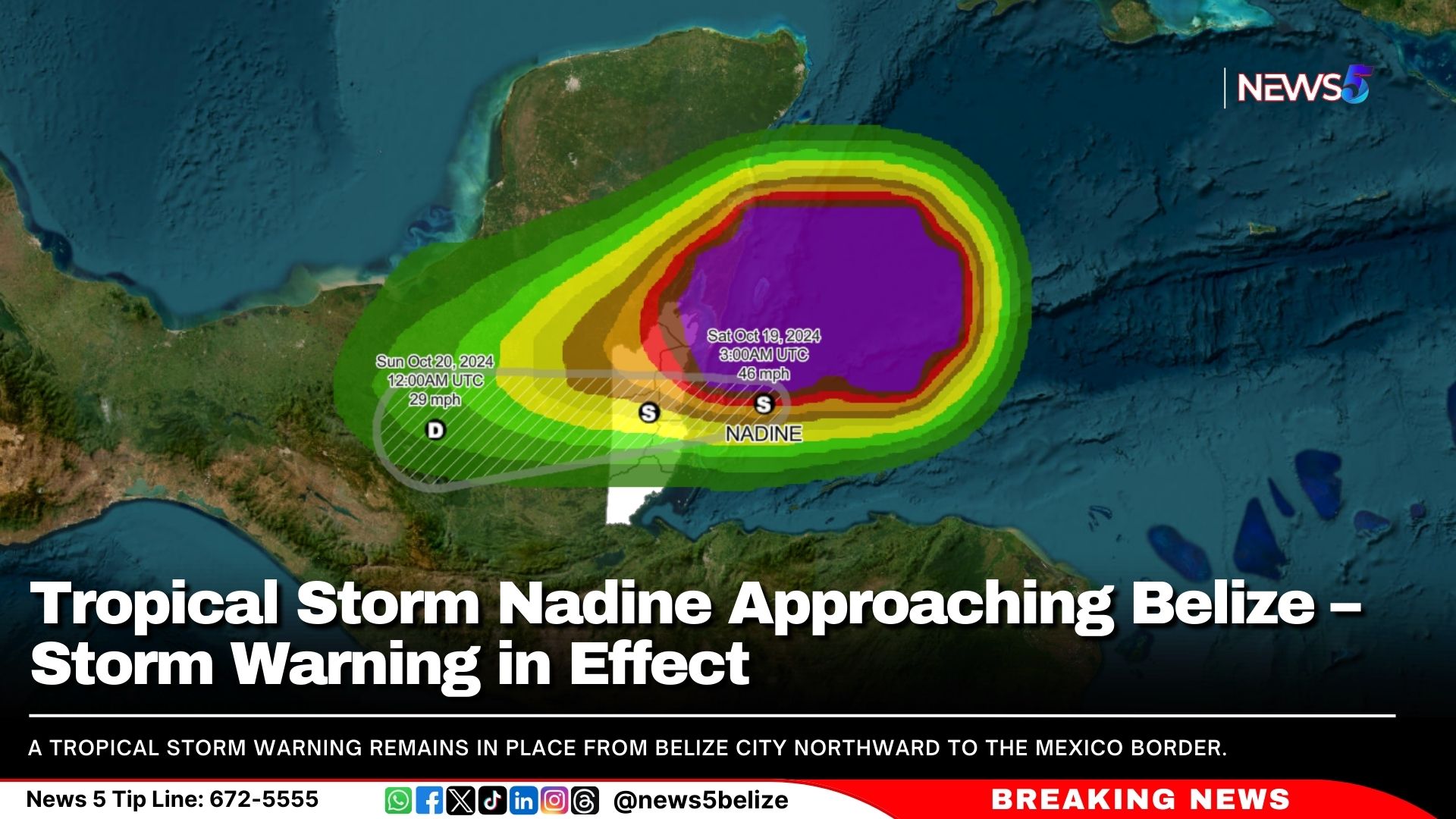
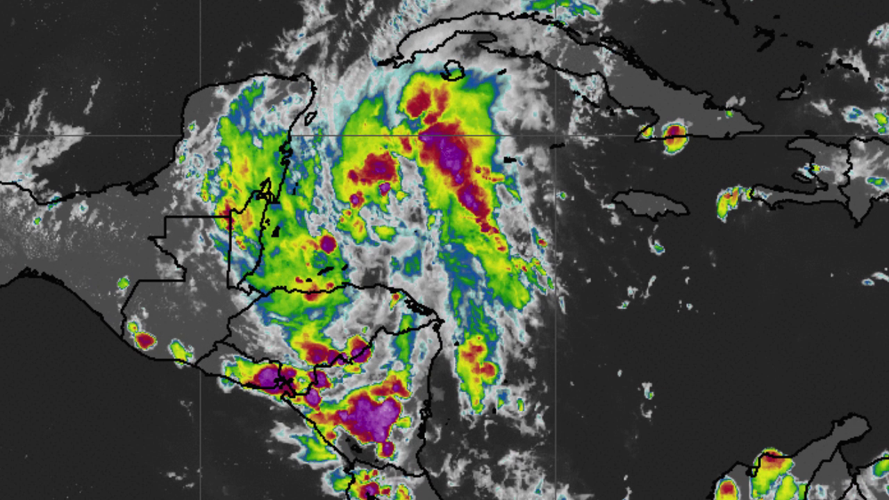
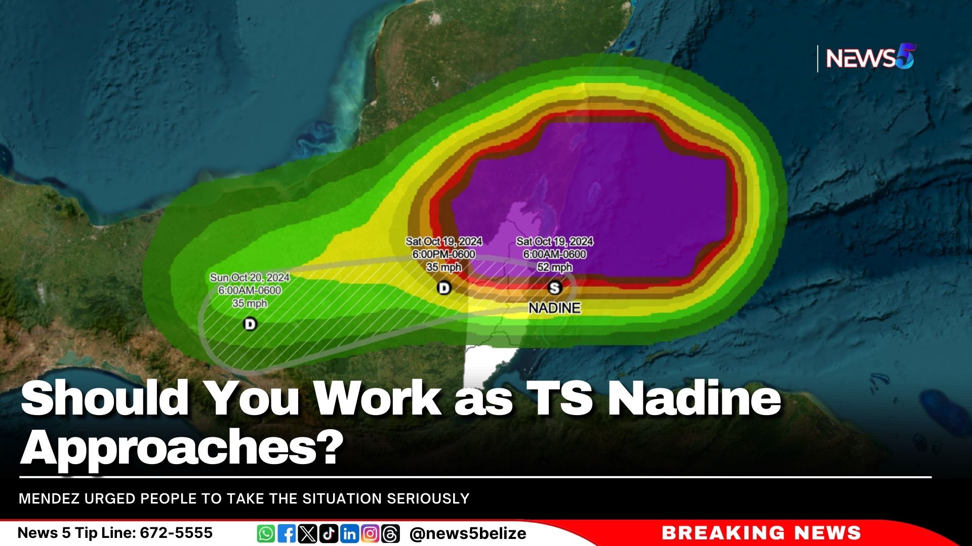
Tropical Nadine is expected to make landfall in a few hours. As of 9 a.m., Nadine was located 25 miles southeast of Belize City, moving west at 8 mph with sustained winds of 50 mph.

The National Meteorological Service (NMS) and the National Emergency Management Organisation (NEMO) held a press conference this morning. During the Q&A, officials were asked for their advice to persons who will be working today.

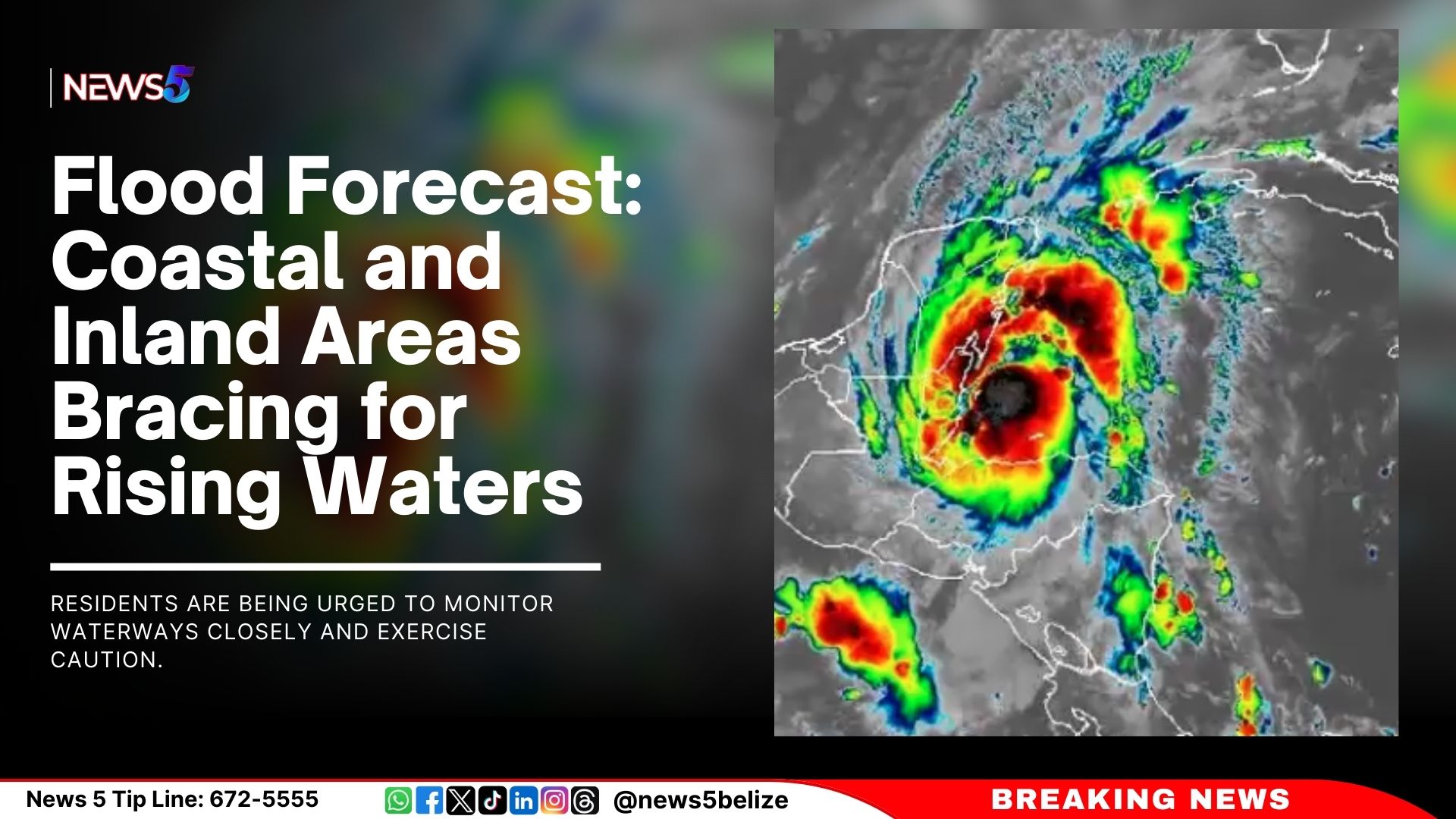
NEMO’s National Emergency Coordinator, Daniel Mendez said their messaging has been clear and consistent regarding the seriousness of the approaching storm. He strongly recommended that businesses close, stressing that it is unwise to assume the storm is small or harmless. “We don’t know what the full impact will be, but we are aware of the potential for flooding,” he noted.

Mendez urged people to take the situation seriously, especially since the system is expected to pass within the next few hours. He explained that teams would be moving through all districts to ensure that residents are informed and advised of the storm’s imminent arrival. “It’s crucial that we act now. We cannot have people engaging in regular activities while we are preparing for the storm’s impact,” Mendez added.

“We cannot, we cannot have people out there doing those activities while we are preparing for the potential of the imminent arrival of the storm in the next few hours.”

When asked for advice for those persons who are being forced to work, Mendez stressed the importance of taking all weather systems seriously, stating that it is unwise to dismiss any storm as a small event that will quickly pass. He acknowledged that the impacts from Tropical Storm Nadine could include not only rainfall but also secondary flooding effects.

Mendez advised families and business owners to be vigilant and prepared, stressing that the situation warrants serious attention. He noted the necessity for businesses to adhere to safety recommendations, although he refrained from specifying mandatory actions at this time.

Tropical Storm Nadine Advisory No. 6

Tropical storm conditions from Nadine continue to impact coastal parts of the Corozal, Belize, and Stann Creek Districts. The National Meteorological Service recorded a wind gust of 43 mph at Half Moon Caye. A Tropical Storm warning remains in effect from Belize City northward to the Mexico border. As of 9:00 a.m., Nadine was located about 25 miles southeast of Belize City, moving westward at 8 mph with maximum sustained winds of 50 mph. The storm is expected to make landfall along the Belizean coast in a few hours, though significant strengthening is not anticipated before landfall.

The primary threat from Nadine remains heavy rainfall, with 1 to 2 inches already recorded. An additional 4 to 6 inches is expected, particularly over northern and central Belize, which could lead to flooding. Strong gusty winds are creating rough sea conditions, and mariners are advised to remain in safe harbor until further notice. Some coastal flooding is expected near or just north of the storm’s landfall area, and gusty winds north of the center may cause minor damage to weak structures. Areas south of Belize City could also experience Tropical Storm conditions, and residents are urged to stay alert.

A Tropical Storm Warning indicates that tropical storm conditions (sustained winds of 39 to 73 mph) are expected within the next six hours. Residents should take immediate action to protect life and property.

Expected Hazards in Belize:
– Rainfall: An additional 4 to 6 inches of rain, particularly in northern and central Belize, could result in localized flooding.
– High Winds: Winds of 50 mph, with higher gusts, may cause damage to structures, crops, and trees.
– Storm Surge: A minor storm surge, generally less than 1 foot, is possible just north of the storm’s landfall area.

The National Emergency Management Organization (NEMO) urges residents in the Corozal, Belize, Orange Walk, and Cayo Districts to finalize preparations as Tropical Storm Nadine approaches. Flooding and high winds are expected. Residents in other districts should stay on high alert.

– Businesses in the Corozal, Orange Walk, and Belize Districts (including San Pedro and Caye Caulker) should consider closing for the day to ensure the safety of employees.
– Essential services will remain open in the Belize, Corozal, and Orange Walk Districts, as well as in San Pedro and Caye Caulker.
– Families and businesses should implement their emergency plans and check food, water, and medical supplies. Ensure the safety of the elderly, people with disabilities, and pets.
– NEMO recommends sheltering in place, given the limited time before landfall. Find a safe location to take shelter.
– Shelters will be opened in the Belize and Cayo Districts and San Pedro Town. Listen for NEMO updates in your district for further details.

Residents are advised to follow updates from NEMO and the National Meteorological Service. The National Emergency Operations Centre is fully activated, and all district emergency operations centers remain on high alert. NEMO’s hotline is 936.

NEMO reminds the public to take all hydrometeorological hazards seriously and work together to ensure community safety and preparedness.

Nadine Expected to Make Landfall Soon 

The National Meteorological Service of Belize (NMS) and the National Emergency Management Organisation (NEMO) held a press conference to provide the latest information regarding Tropical Storm Nadine.

Tropical Storm Nadine is spreading over coastal parts of Corozal, Belize, and Stann Creek Districts, with a warning in effect from Belize City northward to the Mexican border. As of 6 AM, Nadine was located 60 miles east of Belize City, moving west at 9 mph with winds of 45 mph. The storm is expected to make landfall between 9 AM and midday, with further strengthening possible. The main threat is heavy rainfall, with 4 to 6 additional inches expected, leading to possible flooding. Rough seas and strong winds could cause coastal flooding and minor damage. Residents, especially south of Belize City, should remain vigilant.

Since the storm was classified and named Nadine, bands of showers and thunderstorms have intensified, becoming more frequent across the country. Constant rain, with embedded thunderstorms, is now affecting much of the country.

According to Chief Met. Ronald Gordon, in terms of rainfall, 1 to 2 inches have already been recorded, with expectations of an additional 4 to 6 inches as Nadine progresses. He noted that, due to the storm’s broad circulation, focusing on a precise landfall location is not relevant, as the centre is not well defined. Tropical storm force winds, which extend up to 295 miles north of the centre, are affecting areas as far as Cancun. Winds in Belize have so far reached gusts of up to 20 knots, but stronger gusts are expected as the storm moves further onshore, potentially reaching 45 miles per hour.

Gordon says that areas such as Belize City, Caye Caulker, San Pedro, and Corozal are most likely to experience tropical storm-force winds. The core of the storm is expected to move across Belize by midday, rapidly weakening as it moves inland, and potentially dissipating by tomorrow over southern Mexico. Rainfall will persist as the storm moves west but will gradually decrease by tomorrow and into Monday.

He also mentioned the potential for minor coastal flooding, particularly north of the storm’s centre, with water levels rising by about one foot or less. While a significant storm surge is not expected, rainfall could result in localised flooding.

Gordon explained that the winds associated with Tropical Storm Nadine are more spread out, with the stronger winds located farther from the center. He described the system as broad and disorganised, unlike more compact storms where strong winds are concentrated near the center. While Belize has not yet experienced sustained tropical storm-force winds, Gordon said that gusty winds are still expected as the storm approaches.

Gordon said, “I would say that we have had deterioration since last night based on the weather conditions, the rain, and so forth. But certainly, it will get worse. As the morning progresses, I won’t give a specific time. We expect landfall in time between 9 o’clock and midday. So we can look at that window to say that those would be the most severe time or within that time period. We would expect the more severe weather conditions from the system.”

Flood Forecast: Coastal and Inland Areas Bracing for Rising Waters

As of Saturday, October 19, 2024, at 8:05 AM, elevated river levels are expected along coastal areas in the southern parts of the country, and residents are being urged to monitor waterways closely and exercise caution.

In Region 7, the Rio Hondo at Blue Creek North remains at flood stage, with increasing levels forecast for Santa Cruz, San Antonio, San Roman, Douglas, and areas downstream to the coast. The New River at Hill Bank and Tower Hill is also expected to see rising levels, with elevated conditions at Caledonia.

In Region 9, bank full-stage levels are anticipated on the Mopan River at Benque Viejo Town. The Macal River will remain below spillway levels at all Fortis reservoirs, but water levels in San Ignacio are expected to surpass the low-level bridge. Meanwhile, above-normal levels are projected for the Belize River at Double Run, though the Crooked Tree Lagoon will stay below the causeway.

Region 11 is also on high alert as increasing levels are forecast on the Sibun River at Freetown Sibun and the Southern Lagoon at Gales Point Village. The eastern slopes of the Mayan Mountains and the Sittee River at Kendal Bridge will experience above-normal levels, while normal conditions persist at the Swasey and Bladen branches of the Monkey River, Deep River, Rio Grande, Moho River, and the Temash River.

The Ministry of Natural Resources has also advised that the Coastal Road from La Democracia to the Hope Creek junction may be impassable due to excessive rainfall. A flood alert is in effect for the San Ignacio low-level bridge and the Iguana Creek Bridge, which may become impassable due to riverine flooding. Additionally, flood warnings are in place for the Sittee River and its surrounding areas, as well as urbanised low-lying areas in central and northern Belize.

Residents across affected regions are urged to remain vigilant and prepared as flooding is possible. Normal levels are currently expected on the Sarstoon River in Region 13.

Tropical Storm Nadine Approaching Belize – Storm Warning in Effect

Tropical storm conditions from Nadine are now impacting coastal parts of Corozal, Belize, and Stann Creek Districts. A Tropical Storm Warning remains in place from Belize City northward to the Mexico border.

At 6:00 AM, Tropical Storm Nadine was located near latitude 17.3N, longitude 87.3W, about 60 miles east of Belize City. Nadine is moving west at 9 mph, with maximum sustained winds of 45 mph, and may strengthen further before making landfall along the Belize coast between 9:00 AM and noon today.

Key Hazards and Impacts:

– Heavy Rainfall: An additional 4-6 inches of rain is expected, especially in northern and central Belize, increasing the risk of localized flooding.
– High Winds: Winds of 45 mph with higher gusts are expected, potentially causing minor damage to weak structures, trees, and crops.
– Storm Surge: A minor surge of less than 1 foot is expected near and just north of where the system makes landfall.

Residents of Corozal, Orange Walk, Belize, and Cayo Districts should prepare for potential flooding and high winds. Businesses in these areas, including San Pedro and Caye Caulker, are advised to remain closed today for safety. Essential services will remain operational in the affected districts.

Sheltering in Place is recommended due to the short time frame before landfall. However, shelters will open in the Belize and Cayo Districts, as well as San Pedro Town, with more shelters available if needed.

Immediate Actions:
– Activate family and business emergency plans.
– Check your emergency supplies, including food, water, and medical necessities.
– Assist the elderly, people with disabilities, and ensure pet safety.
– Mariners should remain in safe harbor until further notice.

Follow official updates from NEMO and the Met Service. The National Emergency Operations Centre is active, and all District Emergency Operations Centers are on alert. For assistance, contact NEMO’s hotline at 936.

Let’s continue working together to keep our communities safe and prepared!

Tropical Storm Watch Declared for Parts of Belize 

A tropical storm watch has been declared for the Belize, Corozal, and Orange Walk districts. As of three o’clock this afternoon, Potential Tropical Cyclone 15 is heading directly to central Belize. With maximum winds of thirty-five miles per hour, the system may strengthen into a tropical storm with winds up to fifty miles per hour before it makes landfall on Saturday. The biggest concern is the expected downpour—up to eight inches of rain could hit northern and central Belize, bringing a high risk of flooding. Strong gusts will whip up rough seas, so mariners are urged to seek safe harbour immediately. Coastal flooding is also possible in areas north of the storm’s path. Residents from Dangriga to Belize City are advised to stay on high alert, as the storm watch could be extended southward. According to Chief Meteorologist Ronald Gordon, this system has become more organised, with a seventy percent chance of developing into a tropical depression or storm.


Ronald Gordon, Chief Meteorologist, NMS

We have been closely monitoring the potential for development over the Southwestern Caribbean Sea from the early parts of this week. And throughout to this morning, the system has become better organised and currently has a high chance of becoming a tropical depression or a tropical storm before reaching Belize or the Yucatán Peninsula of Mexico tomorrow morning. Currently, the chances are 70 percent of it becoming a tropical storm or depression. Regardless of whether the system becomes a tropical storm or depression, The main threat from the system for the country of Belize is going to be heavy rainfall, and that activity has already started, which we are seeing older bands of showers and thunderstorms moving across the country from the system. Those are expected to continue throughout the evening and tonight and intensify into tomorrow morning. Rainfall estimates at the moment are for about 4 to 8 inches, the higher end, and based on the current trajectory, the highest and most of the rainfall will be in the extreme north of the country.”


NEMO Alerts North Districts on Potential Flooding

NEMO is urging everyone, especially those in flood-prone areas, to have emergency plans and supplies ready. The organization has put district offices on alert and is coordinating with vulnerable communities to prepare for the potential flooding. As of now, schools and airstrips will remain operating as normal. They remind everyone that it’s still in the peak of hurricane season, so it’s crucial to stay informed by following official alerts only. We spoke to NEMO’s National Emergency Coordinator, Daniel Mendez, on this.


                Daniel Mendez

Daniel Mendez, National Emergency Coordinator, NEMO

“The EOC’s in all our districts are planning meetings with their members in preparation for for the potential flood and wind risk. So we have also been reaching out to all the vulnerable communities in the north. This has actually begun. We have been speaking to the communities and the leadership of the communities, informing them of the potential rain and wind. We have started to work with them to ensure that these preparations are in place. So all of our districts are actually meeting now between now and 3 PM. At the national level, we will be conducting a planning meeting with all of the national liaison officers here at the NEMO headquarters in preparation for any activation of all the preparation. We have stops in place in all the district offices, and our personnel will be on standby over the weekend. I really want to stress to the public that if you are in one of these vulnerable locations, if you are in a village that is at risk for flooding, please keep on monitoring and please be prepared to have to implement your action plan. If this should occur. We also are recommending to all residents that we need to start looking at clearing of drains and doing everything we can to minimise any potential flooding to your property.” 


We’ll be tracking the weather of the weekend, and you can find updates on our channel5belize.com website and social media pages. NEMO’s hotline is 936

Tracy Taegar-Panton Defies Shyne, Asserts Strong Support for Unity Convention

The internal power struggle within the United Democratic Party (U.D.P.) has reached a boiling point, with the Alliance for Democracy, led by Albert Area Representative Tracy Taegar-Panton, taking centre stage this weekend. For months, Taegar-Panton and her supporters have been organising what they describe as a Special Unity Convention. That convention is set for this Sunday and is to name Taegar-Panton as the U.D.P. interim leader. And as the U.D.P.’s internal war continues to play out publicly, it’s clear that Taegar-Panton is not backing down. The Alliance claims they have the support of seventeen constituencies. Taegar-Panton says that despite efforts to discredit the Alliance, they are pushing full steam ahead. But, in a hypothetical future, let’s say that the Alliance gets the number of delegates. Let’s say that Taegar-Panton is voted as the so-called interim leader. What happens next? They don’t have the keys to the U.D.P. headquarters. Will they storm the building? The official party’s position is that Panton and her crew are no longer members of the U.D.P. The unity convention does not have the blessing of the U.D.P.’s executive, and as such, the U.D.P. won’t recognise it. So, will that convention be a waste of time and resources? We asked Taegar-Panton.


               Tracy Taegar-Panton

Tracy Taegar-Panton, Area Representative, Albert

“We have not been removed as members of the United Democratic Party because you cannot unilaterally or arbitrarily remove anybody from the party. There’s a process that is outlining the Constitution that tells you how members are removed. That process has not been followed. You can’t declare us to be not UDP. The Constitution also says very clearly that twenty-five percent, or one quarter of the delegates of the National Convention at any time can convene our national convention by petition. We have superseded that threshold. That threshold is one hundred and thirty-two delegates; two hundred and thirty-two delegates signed that petition. I want to assure the Belizean people that everything that we’re doing on Sunday is following the letter off the Constitution because we can’t say that we’re taking action because the democracy of the party is being eroded and then act ultra virus to that. We are following the Constitution, and the Constitution of the party allows for inclusion. It allows for voices of dissent. It allows for a participatory approach to making decisions within this party. And all of that has been thrown out, disregarded, dismissed. And when you don’t agree with the current Leader of the Opposition, he silences you. He removes you, as he has done today, from the House committees. He removes you from the internal committees of the party. He removes you from the chat groups. That, my friends, is not democracy. It is not what democracy looks like. It is a dictatorship. I’m very confident that we will supersede the threshold. It’s a simple majority, fifty percent plus one, that would be two hundred and sixty-five delegates, and I can tell you, as of today, we have a delegate count of over three hundred. We’re not throwing anybody out because we don’t have the mandate to do that. We will get the mandate on Sunday from the highest decision makers of this party, which are our delegates. And when we are given that mandate, we are going to follow the mandate.”


U.D.P. Leader Insists Sunday’s Convention is Not a UDP Event

If the Alliance for Democracy succeeds in naming Tracy Taegar-Panton as “interim leader” and her supporters attempt to storm the United Democratic Party (U.D.P.) headquarters, U.D.P. Leader Moses “Shyne” Barrow says the police will be called in to maintain order. Barrow says that Alliance’s event is not recognised by the U.D.P. He stressed that the party already has an elected leader and executive in place, none of whom support the upcoming convention. Barrow denied any claims of intimidation toward delegates.


            Moses “Shyne” Barrow

Moses “Shyne” Barrow, Leader, U.D.P. 

“We have tried to refrain from legal action, but it is not a UDP anything. So, these people are an entity unto themselves, and while they are expelled members, former members of the party, or whatever they are doing.  has absolutely nothing to do with the UDP proper, so it is not an accurate factual description to refer to these people as the UDP. So, whatever the People’s United Party does or the PNP does, or the Progressive Party or the Alliance Party, is of little concern to me. to the United Democratic Party.”


Paul Lopez

“Why didn’t you file an injunction to stop this convention? You are the executive of the UDP.”


Moses “Shyne” Barrow

“Well, legal advice and political advice – the only injunction that we could have filed was for them not to use the name. But there is no concern of a threat of a viable threat. You can’t stop people from gathering. So the only thing we could stop them from using is the name.  And that option remains on the table going forward to stop them from, you know, using the name.”


Reporter

“What makes a convention though, is the presence of delegates. Do you suspect that there will be a number of UDP delegates present there?”


Moses “Shyne” Barrow

“We have to be rooted in reality.  s upset as Belizeans may become, if we all decide 100, 000 Belizeans decide to vote and vote, it doesn’t matter unless the elections are actually called. You know, we can’t have a citizens elections. Um, even in the instance where, um, Boots Martinez submitted a recall petition.  to the governor general that was rejected.  Um, he could have a recall election if he wants, but it would have no legal impact. So at the end of the day, the rules are the rules. Constitution of the United Democratic Party is the Constitution of the United Democratic Party. And people don’t exist in an organization in an orbit unto themselves. You have to conform to the rules and the constitution of that organization. And when you act outside of that, then you become another organization and we wish you well.”


Opposition Members Go At Each Other During House Debate

Opposition Leader Moses “Shyne” Barrow has replaced Tracy Panton and Patrick Faber on all House committees, following a motion passed today in the House of Representatives. The thirteen committees play a crucial role in reviewing and amending legislation. Barrow nominated himself, Hugo Patt, and Denise “Sista B” Barrow to fill all thirteen committee positions. This is another chapter in the ongoing rift within the United Democratic Party (U.D.P.), with tensions spilling over into the House of Representatives. Today’s debate on the changes was heated, which only added to the party’s internal drama.


Patrick Faber, Area Representative, Collet

“I would have to say whoever is responsible, that it is an asinine decision. So I make the appeal to him and I make the appeal to all right thinking supporters of him, I don’t know if many of that exist. I see my colleague from Corozal north has gone, disappeared, can’t face the music of what his leader is doing in here, shameful. We have to stand up for what is right. We have to. So I make the appeal to him to do what is right for the Belizean people. If you have any iota of respect for what we do for the Belizean people and this process we call democracy, what he has done in the UDP is enough, but now he brings it to this honorable house.”


             Moses “Shyne” Barrow

Moses “Shyne” Barrow, Leader of the Opposition

“For the record, for the last four years, the members from Collet and Albert has rarely ever attended any of the House committee meetings. The record would reflect that their attendance at the house committee meetings has been very poor. The member for Collet lives abroad. He spends most of his time in the United States getting this illusive PHD that he has been getting ever since he resigned in disgrace. He talks about petty and vindictive; he is the reason I am sitting here. I am a first term junior. You sir, if you were so brilliant, you were such a stateman and so great you would be sitting here. You had your opportunity, and it has flown away because of your behavior.”

Exit mobile version