This story was originally published on Earth Observatory
Belize, a small country in Central America, lies east of Guatemala along the Atlantic Ocean. Forests cover roughly 62 percent of its land, making it one of the most forested countries in Central America.
Broadleaf deciduous forests thrive in the limestone soils in the northern part of the country, while tropical rainforests flourish in wet areas in the south. Mangroves line the coastline toward the country’s east, and pine forests grow in areas with well-drained, acidic soils in the Maya Mountains in the southwest.
However, these forested areas have lost ground in recent decades. According to forest cover loss data collected by Landsat satellites and processed by the Global Land Analysis and Discovery (GLAD) laboratory at the University of Maryland, Belize lost 3,020 square kilometers (1,170 square miles) of forest cover between 2001 and 2023, a 17 percent decrease. That’s an area nearly the size of Rhode Island.
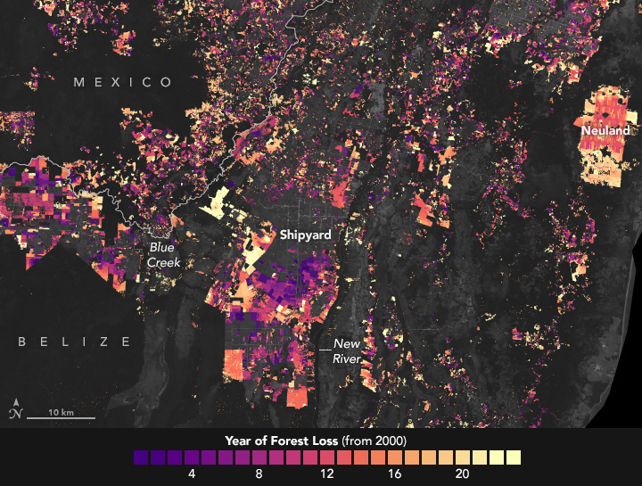
Some of the most noticeable changes occurred in central and northern Belize in the Orange Walk District, the area shown in the map below. Older forest cover loss appears purple, while more recent clearing appears yellow. The rectangular features scattered throughout the images are pastures or cropland, said Emil Cherrington, a NASA scientist who has researched forest cover trends in Belize as part of his work with the NASA-USAID SERVIR program. In this area, many farms grow sugar cane. Production of the increasingly popular crop in Belize has nearly doubled between 2010 and 2020, now accounting for about 8 percent of the country’s GDP.
In this area, farming by Mennonite communities is another important driver of forest loss, especially the largest patches. Mennonites began to immigrate to the communities of Shipyard and Blue Creek in 1958, with the goal of building productive farming communities and living in relative isolation. As the population grew over the decades, farmland became scarce. This drove the establishment of new communities to the south in Indian Creek (1991) and to the east in Neuland (2011), and led to the clearing of many large parcels of forest. Mennonite farms typically raise a mixture of crops and livestock products, including vegetables, fruit, milk, cheese, poultry, beef, and pork.
Most of the forest loss shown in this map is the product of intentional clearing by farmers for crops or livestock. However, forests degraded by other factors—such as fires, insect infestations, or hurricanes—can also appear as forest cover loss in these data, said Santos Chicas, a Belizean remote sensing scientist based at Kyushu University who has studied Belize’s susceptibility to wildfires. Forest losses driven by these other factors generally appear in patches that are blotchy and less rectilinear than forests cleared for agriculture.
One of the largest areas of forest loss within a protected area occurred in the Mountain Pine Ridge Forest Reserve in south-central Belize. Landsat observed widespread change there because a potent pine bark beetle infestation killed up to 90 percent of the reserve’s pine trees between 2000 and 2002. This die-off was followed by waves of wildfires, often ignited by lightning, in subsequent years. Reserve managers also routinely conducted controlled burns to protect the ecosystem from large and destructive wildfires.
“Other ecosystems susceptible to fires are lowland savanna and broadleaved rainforests, especially in the months of April and May during dry years,” Chicas said. “Fires can escape from farmers, who use it as a form of land management.”
Researchers are seeing some evidence that the rate of deforestation—excluding forest losses associated with wildfires, insects, or other natural factors—is trending downward. In a study published in 2010, Cherrington assessed that Belize lost roughly 100 square kilometers (40 square miles) of forest per year between 1980 and 2010.
“Our latest numbers show the rate of forest loss is down to about 80 square kilometers per year over the past decade—an improvement but a modest one,” said Edgar Correa, an officer with the Belize Forest Department. He added that the number needs to drop even lower to meet the 2030 sustainable development goals adopted by all United Nations member states in 2015.
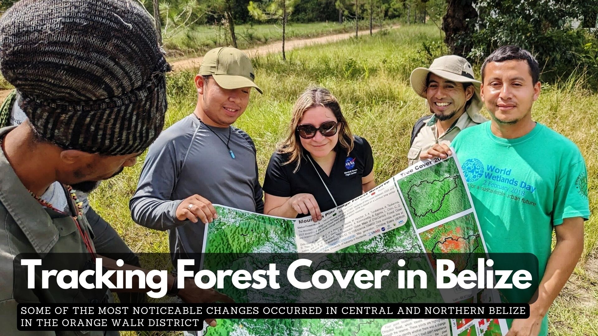
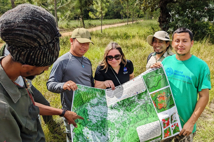
To aid progress toward those goals and others established as part of the United Nations Framework Convention on Climate Change agreements, Cherrington has worked closely with SERVIR to share information, tools, and expertise from NASA with Belize’s forest and marine monitoring agencies. In 2023, for instance, SERVIR held a workshop with the Belize Forest Department focused on developing approaches to integrating automated land classification and change detection information from Landsat, including a mapping tool called LandTrendr, into Belize’s national forest monitoring system. The photograph above shows workshop participants looking at a land cover validation map of the Mountain Pine Ridge Forest Reserve.
“One of the patterns that comes through clearly in the satellite data is how the protected areas in Belize have been so effective in heading off deforestation in most areas,” Cherrington said. As seen in the map at the top of the page, Belize has dozens of protected areas, including national parks, nature reserves, natural monuments, forest reserves, and wildlife sanctuaries that serve as sharp buffers against forest loss.
There are some exceptions. “We see some areas, typically along the border with Guatemala, where people are making incursions into protected areas to farm livestock and practice slash-and-burn agriculture,” said Chicas, who has used Landsat to track the phenomenon in the Maya Mountains in southeastern Belize.
“Big challenges certainly remain for Belize,” added Cherrington. “But this is a country where I see deep interest across a broad spectrum of society and government in tapping into remote sensing data and keeping forests intact.”
Editor’s Note: Read an accompanying story about forest cover loss in Guatemala.
NASA Earth Observatory images by Wanmei Liang, using forest loss data from the University of Maryland and protected areas from Protected Planet. Photograph courtesy of Emil Cherrington (NASA/SERVIR). Story by Adam Voiland.