Advisory 8: Tropical Storm Nadine Weakens

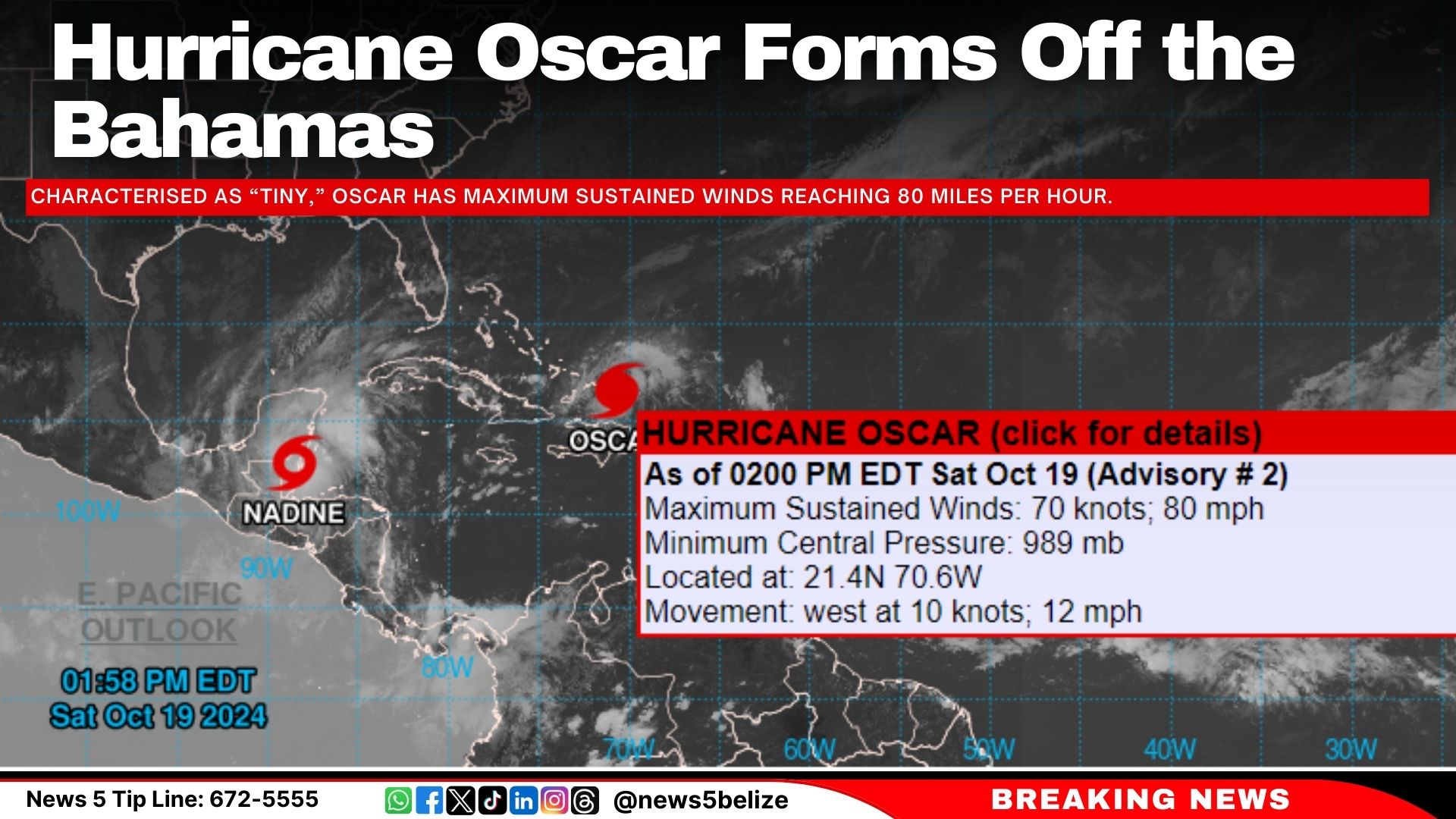
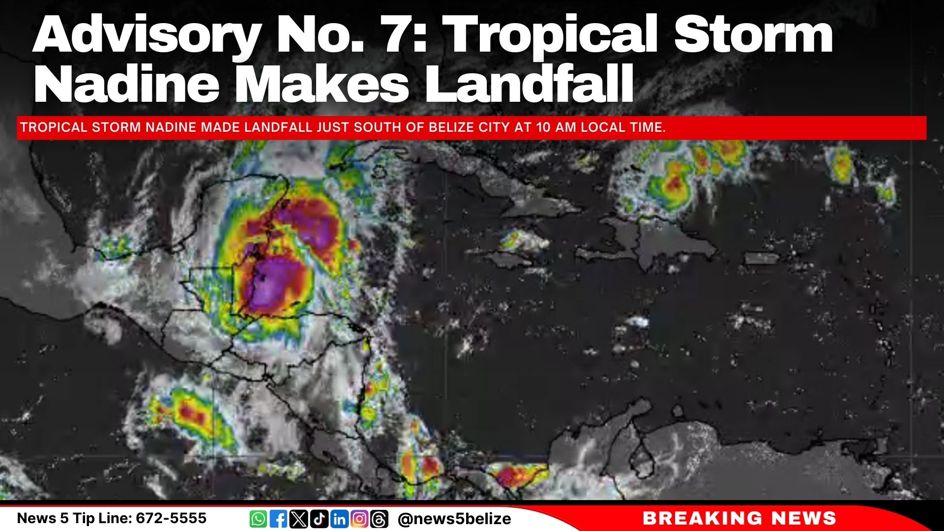
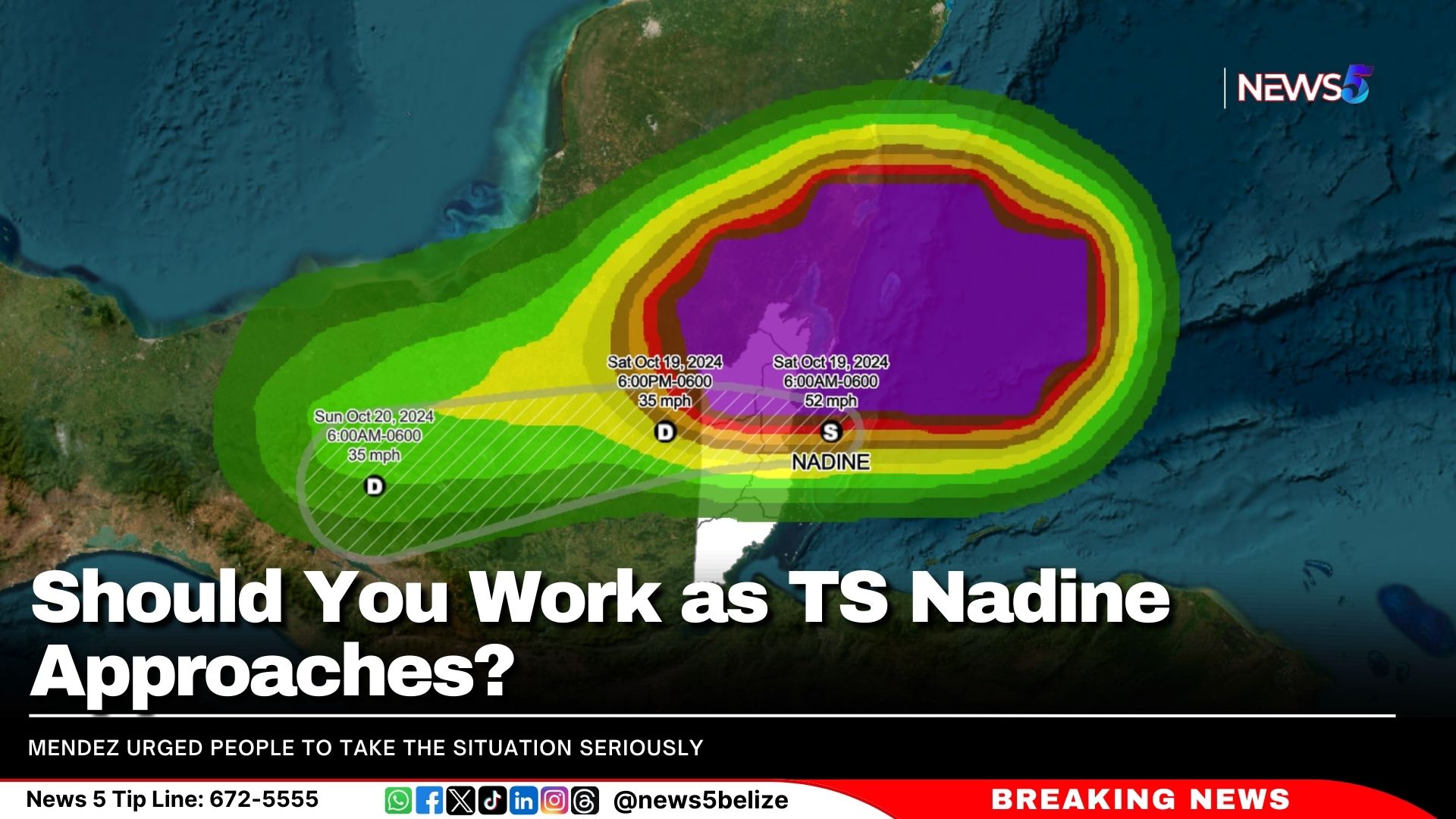
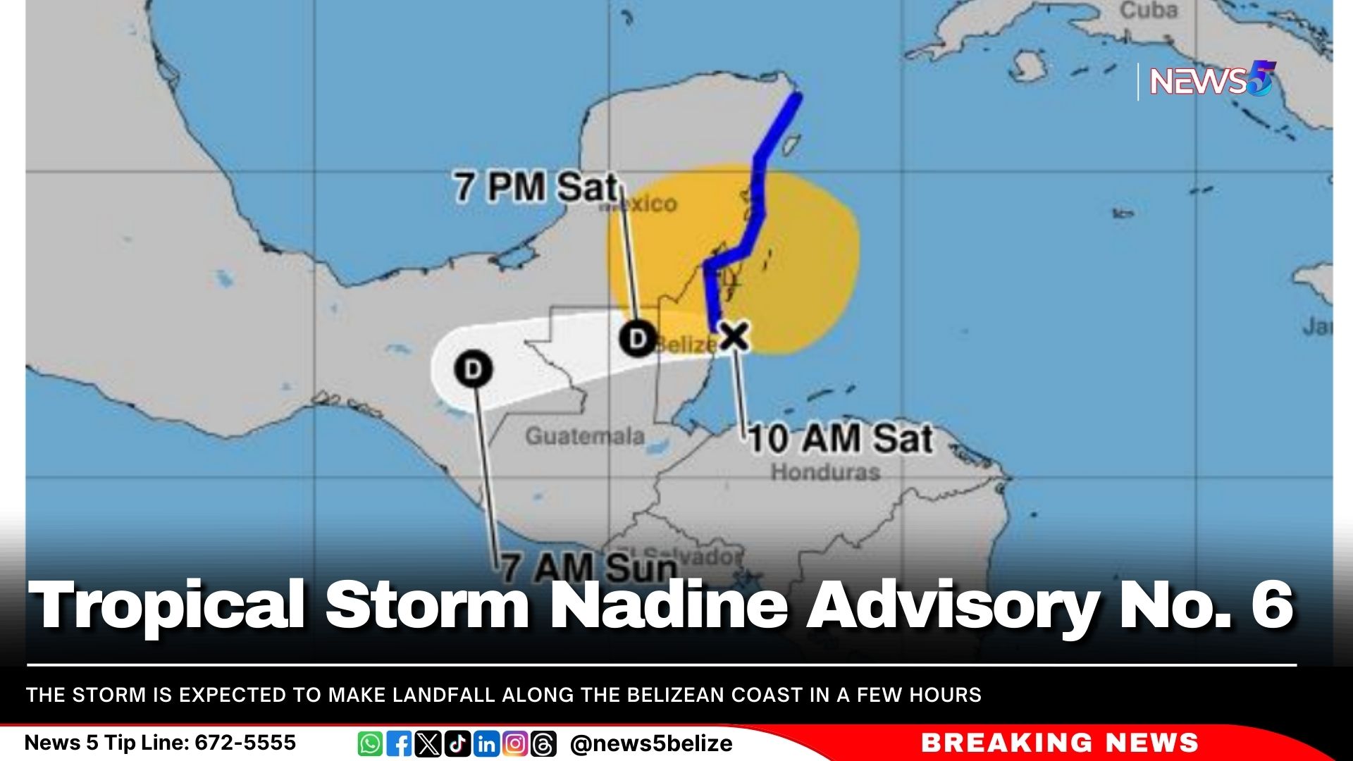
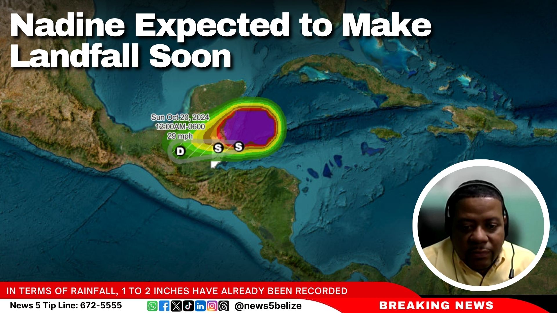
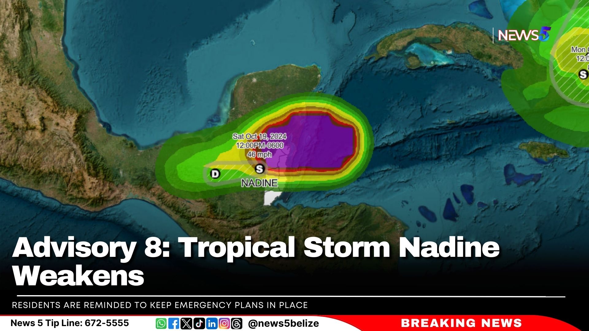
As of 3:00 PM on Saturday, October 19, 2024, Tropical Storm Nadine is gradually weakening as it continues to move inland. Despite this, tropical storm conditions are still affecting parts of the Corozal, Belize, and Orange Walk Districts. A Tropical Storm warning remains in effect from Belize City northward to the Mexico border.

At 3:00 PM, Nadine was located approximately 80 miles west of Belize City at latitude 17.4N and longitude 89.4W, moving westward at 13 mph with maximum sustained winds of 45 mph. This westward motion is expected to continue for the remainder of the day.

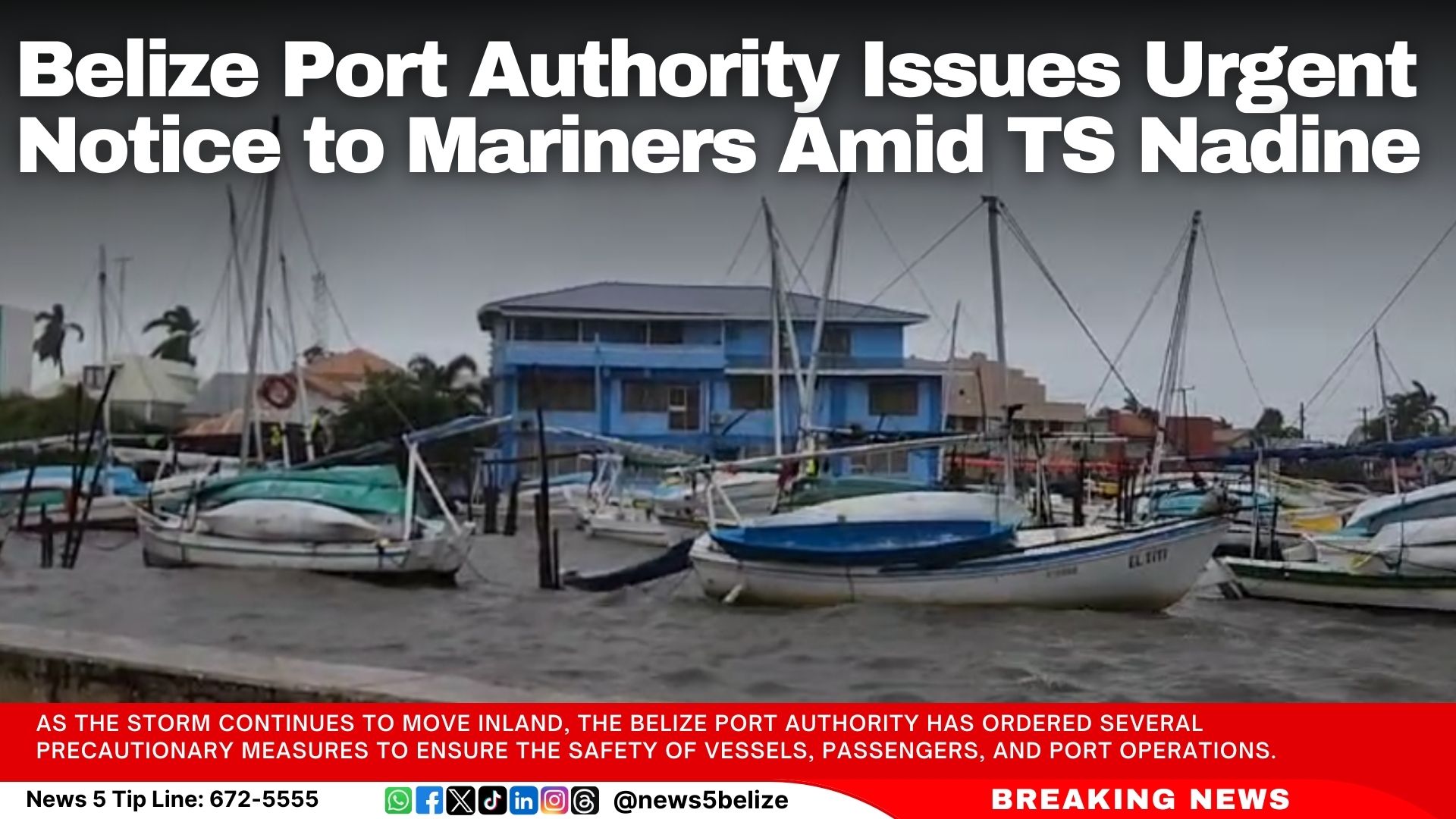
The primary concern remains heavy rainfall. Rainfall totals of 3 to 6 inches have already been recorded, with an additional 2 to 4 inches possible, especially over northern and central Belize. This raises the risk of flooding. Strong gusty winds are still creating rough seas, and mariners are advised to stay in safe harbor until the winds die down later this evening. Gusty winds in central and northern districts may continue for the next 2 to 3 hours and could cause minor damage to weak structures.

Hazards Expected to Affect Belize:
– Excess Rainfall: An additional 2 to 4 inches of rain is expected, which could lead to localized flooding in northern and central Belize.
– High Winds: Winds of 45 mph, with stronger gusts, may cause damage to structures, crops, and trees.

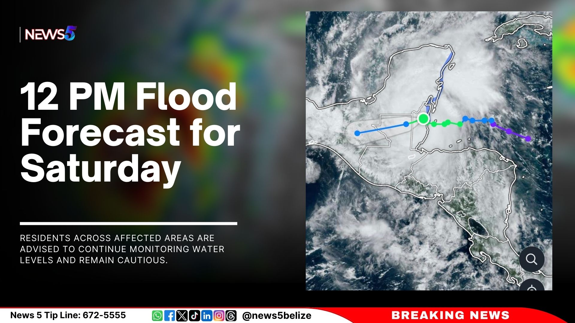
Flood Warnings are in Effect for:
– Coastal Road from La Democracia to Hope Creek Junction
– San Ignacio low-level bridge and Iguana Creek Bridge
– Sittee River and surrounding areas
– Rivers in central and northern Belize, including Rio Hondo, New River, Booth’s River, Rio Bravo, Mopan, Macal, and Belize Rivers, as well as those on the eastern slopes of the Maya Mountains.

The National Emergency Management Organization (NEMO) urges residents in the Corozal, Belize, Orange Walk, and Cayo Districts to make use of shelters if necessary. Other districts should remain on high alert. Businesses in the Corozal, Orange Walk, and Belize Districts, including San Pedro and Caye Caulker, should remain closed. Essential services, however, will stay open in these areas.

Residents are reminded to keep emergency plans in place, ensure they have supplies of food, water, and medicine, and check on vulnerable individuals, including the elderly and those with disabilities. Shelters are available in affected districts, and water taxi operations remain suspended.

The Philip Goldson International Airport (PGIA) remains open, but travelers should expect delays.


Cuba Faces Second Nationwide Blackout as Electrical Grid Collapses Again

Cuba was plunged into darkness early Saturday morning after its national electrical grid collapsed for the second time in 24 hours, according to state-run media. The grid operator, UNE, reported the “total disconnection of the national electro-energetic system” at 6:15 a.m., leaving the entire island without power.

The blackout came just hours after Cuban authorities announced they had begun restoring service following a previous collapse on Friday. While some progress was made in bringing electricity back to critical areas, including hospitals and parts of Havana, most of the country’s 10 million residents were still without power by Saturday afternoon.

Throughout Havana, traffic lights remained off, commerce was halted, and long lines formed at state-subsidised stores as Cubans waited to purchase essential items like bread. The country’s top electricity official, Lazaro Guerra, stated that efforts were underway to raise capacity and restart power plants, though he could not guarantee that full restoration would be achieved by the end of the day.

Confusion arose when state-run outlet CubaDebate reported a second grid collapse, while Guerra described it as a more localised issue, not directly confirming another total failure.

Cuba’s grid first failed around midday on Friday after one of its largest power plants shut down. The country has been grappling with worsening blackouts for weeks, which the government attributes to ageing infrastructure, fuel shortages, and increased demand. Strong winds from Hurricane Milton last week complicated efforts to deliver fuel from offshore to power plants.


Hurricane Oscar Forms Off the Bahamas

Hurricane Oscar has formed off the coast of the Bahamas, according to the National Hurricane Center (NHC) in Miami. Characterised as “tiny,” Oscar is currently located approximately 165 miles east-southeast of the Bahamas and about 470 miles east of Camaguey City in Cuba, with maximum sustained winds reaching 80 miles per hour.

In response to the storm, the government of Cuba has issued a Hurricane Watch for the provinces of Guantanamo, Holguin, and Las Tunas.

The latest advisory from the NHC warns of locally heavy rainfall that may affect the Turks and Caicos Islands and the southeastern Bahamas later today, with conditions expected to spread to eastern Cuba by Sunday.

Additionally, the NHC is also monitoring Tropical Storm Nadine, which is currently situated just inland over Belize.

Belize Port Authority Issues Urgent Notice to Mariners Amid TS Nadine

The Belize Port Authority has issued an urgent advisory to all mariners, boat owners, and port facility operators in light of Tropical Storm Nadine, which is currently affecting the country. A Tropical Storm Warning is in effect from Belize City northward to the border with Mexico, bringing heavy rainfall, strong winds, rough seas, and the potential for flooding, particularly in northern and central districts.

As the storm continues to move inland, the Belize Port Authority has ordered several precautionary measures to ensure the safety of vessels, passengers, and port operations.

Suspension of Water Taxi Operations
All water taxi services within the affected areas have been suspended until further notice. Operators are instructed to immediately cease operations and prioritize the safety of passengers and staff.

Guidelines for Vessel Owners and Operators
All vessels in the affected zones are advised to remain moored in safe harbor until the situation improves. Vessel owners should check and secure mooring lines and remove any loose items from decks to prevent damage. Mariners are urged to stay updated on official weather reports and advisories from the Belize Port Authority and the National Emergency Management Organization (NEMO).

Port Facilities Precautions
Port operators in the impacted areas should secure all cargo and fasten loose materials in preparation for high winds and potential flooding. Operations should be limited or suspended if weather conditions deteriorate to unsafe levels.

The Belize Port Authority is closely monitoring the situation and will provide updates as needed. Mariners are encouraged to stay tuned to local radio stations and VHF radio advisories for the latest information.

12 PM Flood Forecast for Saturday

As of 12:00 PM, the flood outlook for the next 24 hours indicates elevated river levels are expected for the Sibun River at Freetown Sibun. In Region 7, residents are urged to monitor water levels and exercise caution. On the Rio Hondo at Blue Creek North, flood levels are expected to continue, with increasing levels forecast downstream at Santa Cruz, San Antonio, San Roman, Douglas, and toward the coast. The New River at Hill Bank and Tower Hill will see rising levels, while elevated levels are expected at Caledonia.

In Region 9, the Mopan River at Benque Viejo Town is expected to reach bank full stage. The Macal River’s Fortis reservoirs at Chalillo and Mollejon are projected to remain below spillway, but Vaca will exceed the spillway, and the low-level bridge at San Ignacio will also be affected. The Belize River at Double Run will see above-normal levels, while the Crooked Tree Lagoon’s levels are expected to remain below the causeway.

In Region 11, the Sibun River at Freetown Sibun will experience increasing but still below-normal levels. The Southern Lagoon at Gales Point Village will see rising levels. Watersheds on the eastern slopes of the Maya Mountains and the Sittee River at Kendal Bridge will continue to see above-normal levels. Below-normal levels are expected for the Swasey and Bladen branches of the Monkey River, while normal levels are forecast for the Deep River at Medina Bank, the Rio Grande at San Pedro Columbia and Big Falls, and the Moho River at Blue Creek South and Jordan. Similarly, the Temash River at Crique Sarco will maintain normal levels.

In Region 13, normal levels are expected on the Sarstoon River. Residents across affected areas are advised to continue monitoring water levels and remain cautious.

Advisory No. 7: Tropical Storm Nadine Makes Landfall

Tropical Storm Nadine made landfall just south of Belize City at 10 AM local time. However, tropical storm conditions continue to impact parts of the Corozal, Belize, and Orange Walk Districts. A Tropical Storm Warning remains in effect from Belize City northward to the Mexico border. As of 12 PM, Nadine was located near latitude 17.6N, longitude 88.5W, or about 20 miles west-northwest of Belize City, moving westward at 8 mph with sustained winds of 50 mph. The storm is expected to weaken as it moves further inland throughout the day.

The primary concern with Nadine remains heavy rainfall. Some areas have already received 3 to 5 inches of rain, with an additional 2 to 4 inches expected, particularly over northern and central Belize. This will likely result in flooding. Strong gusty winds continue to produce rough sea conditions, and mariners are advised to remain in safe harbor until conditions improve. Gusty winds will persist in central and northern districts for another 3 to 6 hours and could cause minor damage to weak structures.

Hazards Expected to Affect Belize:
– Excess Rainfall: An additional 2 to 4 inches of rain is expected, mainly in northern and central Belize, increasing the risk of localized flooding.
– High Winds: Winds of up to 50 mph, with higher gusts, are expected in the impacted areas, potentially causing damage to structures, crops, and trees.

Flood Alerts:
– Coastal Road from La Democracia to Hope Creek Junction
– San Ignacio low-level bridge and Iguana Creek Bridge
– Sittee River and surrounding areas

Flood Warnings:
– Urbanized flood warnings are in effect for low-lying areas in central and northern Belize.
– Riverine flood warnings are in effect for rivers in the north, central areas, and the Maya Mountains.

The National Emergency Management Organization (NEMO) urges residents of Corozal, Belize, Orange Walk, and Cayo Districts to remain in shelter. Other districts should remain on high alert.

– Businesses in Corozal, Orange Walk, and Belize Districts (including San Pedro and Caye Caulker) should remain closed until Tropical Storm Nadine has passed. Employers are urged to ensure the safety of their employees.
– Essential services will remain open in Belize, Corozal, and Orange Walk Districts, as well as in San Pedro and Caye Caulker.
– Families and businesses should implement emergency plans, ensuring that food, water, and medical supplies are ready. Check on the elderly, those with disabilities, and safeguard pets.
– Shelters are open in Belize, Cayo Districts, and San Pedro Town as needed. Follow NEMO announcements for shelter information in your district.
– The Belize Port Authority has suspended water taxis and advised the safe mooring of vessels.
– The Philip Goldson International Airport remains operational, though flight delays may occur.

Residents should follow official updates from NEMO and the National Meteorological Service. The National Emergency Operations Centre is activated, and District Emergency Operations centres remain on high alert. For assistance, NEMO’s hotline is 936. Let’s work together to keep our communities safe and prepared!

PGIA Operational; Passengers Urged to Remain Patient Amid TS Nadine

The Belize Department of Civil Aviation advises that, after consultation, the Philip Goldson International Airport remains operational with no expected cancellation of international flights. Domestic flights will be allowed depending on weather conditions. The travelling public, both domestic and international, is asked to remain calm and practice patience as there may be flight delays and/or cancellations dependent on the weather.

Press Release

Should You Work as TS Nadine Approaches? 

Tropical Nadine is expected to make landfall in a few hours. As of 9 a.m., Nadine was located 25 miles southeast of Belize City, moving west at 8 mph with sustained winds of 50 mph.

The National Meteorological Service (NMS) and the National Emergency Management Organisation (NEMO) held a press conference this morning. During the Q&A, officials were asked for their advice to persons who will be working today.

NEMO’s National Emergency Coordinator, Daniel Mendez said their messaging has been clear and consistent regarding the seriousness of the approaching storm. He strongly recommended that businesses close, stressing that it is unwise to assume the storm is small or harmless. “We don’t know what the full impact will be, but we are aware of the potential for flooding,” he noted.

Mendez urged people to take the situation seriously, especially since the system is expected to pass within the next few hours. He explained that teams would be moving through all districts to ensure that residents are informed and advised of the storm’s imminent arrival. “It’s crucial that we act now. We cannot have people engaging in regular activities while we are preparing for the storm’s impact,” Mendez added.

“We cannot, we cannot have people out there doing those activities while we are preparing for the potential of the imminent arrival of the storm in the next few hours.”

When asked for advice for those persons who are being forced to work, Mendez stressed the importance of taking all weather systems seriously, stating that it is unwise to dismiss any storm as a small event that will quickly pass. He acknowledged that the impacts from Tropical Storm Nadine could include not only rainfall but also secondary flooding effects.

Mendez advised families and business owners to be vigilant and prepared, stressing that the situation warrants serious attention. He noted the necessity for businesses to adhere to safety recommendations, although he refrained from specifying mandatory actions at this time.

Tropical Storm Nadine Advisory No. 6

Tropical storm conditions from Nadine continue to impact coastal parts of the Corozal, Belize, and Stann Creek Districts. The National Meteorological Service recorded a wind gust of 43 mph at Half Moon Caye. A Tropical Storm warning remains in effect from Belize City northward to the Mexico border. As of 9:00 a.m., Nadine was located about 25 miles southeast of Belize City, moving westward at 8 mph with maximum sustained winds of 50 mph. The storm is expected to make landfall along the Belizean coast in a few hours, though significant strengthening is not anticipated before landfall.

The primary threat from Nadine remains heavy rainfall, with 1 to 2 inches already recorded. An additional 4 to 6 inches is expected, particularly over northern and central Belize, which could lead to flooding. Strong gusty winds are creating rough sea conditions, and mariners are advised to remain in safe harbor until further notice. Some coastal flooding is expected near or just north of the storm’s landfall area, and gusty winds north of the center may cause minor damage to weak structures. Areas south of Belize City could also experience Tropical Storm conditions, and residents are urged to stay alert.

A Tropical Storm Warning indicates that tropical storm conditions (sustained winds of 39 to 73 mph) are expected within the next six hours. Residents should take immediate action to protect life and property.

Expected Hazards in Belize:
– Rainfall: An additional 4 to 6 inches of rain, particularly in northern and central Belize, could result in localized flooding.
– High Winds: Winds of 50 mph, with higher gusts, may cause damage to structures, crops, and trees.
– Storm Surge: A minor storm surge, generally less than 1 foot, is possible just north of the storm’s landfall area.

The National Emergency Management Organization (NEMO) urges residents in the Corozal, Belize, Orange Walk, and Cayo Districts to finalize preparations as Tropical Storm Nadine approaches. Flooding and high winds are expected. Residents in other districts should stay on high alert.

– Businesses in the Corozal, Orange Walk, and Belize Districts (including San Pedro and Caye Caulker) should consider closing for the day to ensure the safety of employees.
– Essential services will remain open in the Belize, Corozal, and Orange Walk Districts, as well as in San Pedro and Caye Caulker.
– Families and businesses should implement their emergency plans and check food, water, and medical supplies. Ensure the safety of the elderly, people with disabilities, and pets.
– NEMO recommends sheltering in place, given the limited time before landfall. Find a safe location to take shelter.
– Shelters will be opened in the Belize and Cayo Districts and San Pedro Town. Listen for NEMO updates in your district for further details.

Residents are advised to follow updates from NEMO and the National Meteorological Service. The National Emergency Operations Centre is fully activated, and all district emergency operations centers remain on high alert. NEMO’s hotline is 936.

NEMO reminds the public to take all hydrometeorological hazards seriously and work together to ensure community safety and preparedness.

Nadine Expected to Make Landfall Soon 

The National Meteorological Service of Belize (NMS) and the National Emergency Management Organisation (NEMO) held a press conference to provide the latest information regarding Tropical Storm Nadine.

Tropical Storm Nadine is spreading over coastal parts of Corozal, Belize, and Stann Creek Districts, with a warning in effect from Belize City northward to the Mexican border. As of 6 AM, Nadine was located 60 miles east of Belize City, moving west at 9 mph with winds of 45 mph. The storm is expected to make landfall between 9 AM and midday, with further strengthening possible. The main threat is heavy rainfall, with 4 to 6 additional inches expected, leading to possible flooding. Rough seas and strong winds could cause coastal flooding and minor damage. Residents, especially south of Belize City, should remain vigilant.

Since the storm was classified and named Nadine, bands of showers and thunderstorms have intensified, becoming more frequent across the country. Constant rain, with embedded thunderstorms, is now affecting much of the country.

According to Chief Met. Ronald Gordon, in terms of rainfall, 1 to 2 inches have already been recorded, with expectations of an additional 4 to 6 inches as Nadine progresses. He noted that, due to the storm’s broad circulation, focusing on a precise landfall location is not relevant, as the centre is not well defined. Tropical storm force winds, which extend up to 295 miles north of the centre, are affecting areas as far as Cancun. Winds in Belize have so far reached gusts of up to 20 knots, but stronger gusts are expected as the storm moves further onshore, potentially reaching 45 miles per hour.

Gordon says that areas such as Belize City, Caye Caulker, San Pedro, and Corozal are most likely to experience tropical storm-force winds. The core of the storm is expected to move across Belize by midday, rapidly weakening as it moves inland, and potentially dissipating by tomorrow over southern Mexico. Rainfall will persist as the storm moves west but will gradually decrease by tomorrow and into Monday.

He also mentioned the potential for minor coastal flooding, particularly north of the storm’s centre, with water levels rising by about one foot or less. While a significant storm surge is not expected, rainfall could result in localised flooding.

Gordon explained that the winds associated with Tropical Storm Nadine are more spread out, with the stronger winds located farther from the center. He described the system as broad and disorganised, unlike more compact storms where strong winds are concentrated near the center. While Belize has not yet experienced sustained tropical storm-force winds, Gordon said that gusty winds are still expected as the storm approaches.

Gordon said, “I would say that we have had deterioration since last night based on the weather conditions, the rain, and so forth. But certainly, it will get worse. As the morning progresses, I won’t give a specific time. We expect landfall in time between 9 o’clock and midday. So we can look at that window to say that those would be the most severe time or within that time period. We would expect the more severe weather conditions from the system.”

Exit mobile version