Beryl Rapidly Strengthens into First Hurricane 

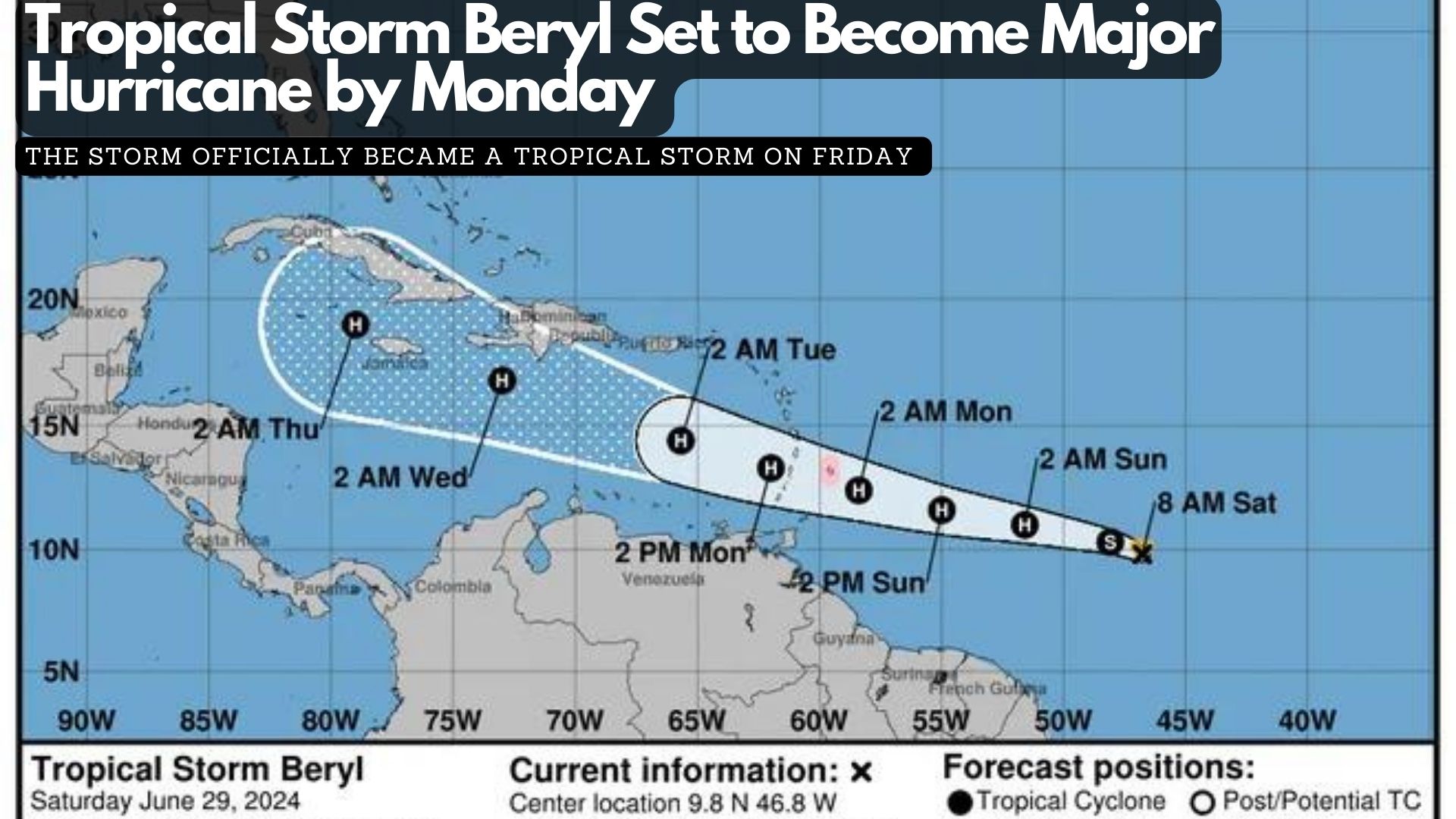
The National Hurricane Center is now tracking Hurricane Beryl, currently less than 1,000 miles east of the Caribbean.

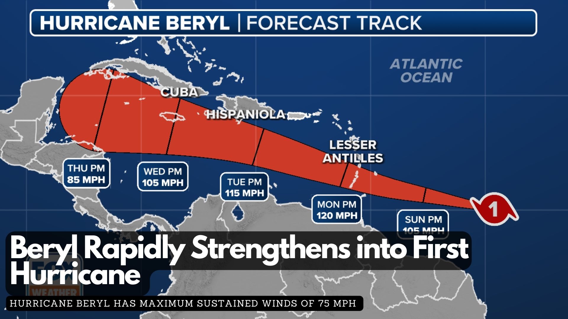
The second named storm of the 2024 Atlantic hurricane season rapidly intensified from a tropical depression to a tropical storm and then to a hurricane within 24 hours, aided by favorable atmospheric conditions.

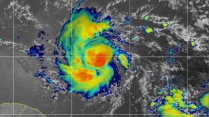
According to the latest report from the National Hurricane Center, Hurricane Beryl has maximum sustained winds of 75 mph and a minimum central pressure below 992 MB, classifying it as a Category 1 hurricane on the Saffir-Simpson Hurricane Wind Scale. This early season hurricane formation is unusual, as the average date for the first hurricane in the Atlantic basin is August 11.

Water temperatures in parts of the central Atlantic are more typical of August and September, and Beryl’s small size has allowed it to avoid Saharan dust and adverse upper-level winds.

A Hurricane Warning is in effect for Barbados, while other nearby islands, including St. Lucia, Grenada, St. Vincent and the Grenadine Islands, Martinique, Dominica, and Tobago, are under watches.

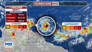
Damaging winds, both tropical-storm-force and hurricane-force, extend up to 45 miles from the center. On its current trajectory, Beryl will impact the Windward Islands with damaging wind gusts over the next 72 hours as it moves west or west-northwest.

The latest forecast from the NHC indicates that winds could reach up to 120 mph in the eastern Caribbean, potentially upgrading Beryl to a major Category 3 hurricane. In addition to hurricane-force winds, the storm is expected to bring torrential rains, with forecast totals of 3-6 inches across Barbados and the affected Windward Islands, likely causing localised flooding.

The NHC has also upgraded its storm surge forecast, now predicting a “life-threatening” surge that could raise water levels by 5 to 7 feet above normal tide levels in areas of onshore flow.

Barbados Braces for Beryl’s Impact

As Barbados braces for severe weather in the next 48 hours, Prime Minister Mia Amor Mottley is urging Barbadians to stay prepared and vigilant as the country braces for Beryl’s impact.

In a video statement tonight, the Prime Minister mentioned meeting with various government departments and agencies earlier today to ensure readiness for any eventualities. She also encouraged Barbadians to look out for each other within their communities.

The Barbados Meteorological Services has issued a Hurricane Watch for Barbados, as Tropical Storm Beryl is anticipated to strengthen into a hurricane before reaching the island late Sunday night.

Residents should prepare for strong winds that could damage homes and properties, along with potential flash flooding, especially in flood-prone areas. Severe thunderstorms may also disrupt power and utility services.

Marine conditions are expected to worsen, with a small craft and high surf warning already in effect due to above-normal sea swells anticipated from Sunday night.

The public is advised to follow guidance from the Department of Emergency Management and local officials. Stay informed through the Barbados Meteorological Services, Department of Emergency Management, and Government Information Service websites, as well as their social media channels and local media.

Tropical Storm Beryl Set to Become Major Hurricane by Monday

Tropical Storm Beryl formed Friday evening in the Atlantic, east of the Windward Islands, and is projected to become a “dangerous major” hurricane by Monday, according to the National Hurricane Center.

As the second named storm of the 2024 Atlantic hurricane season, Beryl is anticipated to reach hurricane status by Saturday night or Sunday morning as it moves westward. The storm officially became a tropical storm on Friday, approximately 1,100 miles southeast of the Windward Islands at the eastern end of the Caribbean.

As of the hurricane center’s 11 a.m. advisory on Saturday, Beryl was moving at about 23 mph, with maximum sustained winds of 65 mph. The center predicts that Beryl will strengthen into a hurricane by late Saturday or early Sunday and continue to intensify, reaching major hurricane status with winds of 111 mph or more before its center reaches the Windward Islands on Monday morning. The atmosphere and ocean conditions along Beryl’s path are described as “abnormally favorable for strengthening.”

However, conditions may become less favorable after the storm enters the Caribbean, where it could encounter disruptive winds that might prevent further strengthening, the center noted this morning.

Tropical Storm Beryl on NOAA Satellite on Saturday morning.

Beryl is currently 820 miles east-southeast of Barbados, and tropical storm-force winds are expected to extend 45 miles outward from the center. The storm could bring heavy rain, hurricane-force winds, and dangerous storm surges and waves as it crosses the Windward Islands on Sunday night into Monday. A hurricane watch has been issued for Barbados, and more watches are expected later Saturday as the system moves further into the Lesser Antilles, which include the Windward Islands, Leeward Islands, and Leeward Antilles.

Barbados and nearby islands could receive 3 to 6 inches of rain, with localized flooding in vulnerable areas and life-threatening surf and rip currents. People in the central and western Caribbean should monitor the storm’s progress, keeping in mind that the forecast’s margin of error can be significant four or five days out.

By Sunday evening, as Beryl moves into the Caribbean Sea, it could have winds up to 105 mph. Although atmospheric conditions in June are typically not conducive to storm strengthening, some computer models are “quite aggressive” and suggest that Beryl could be a major hurricane before reaching the Windward Islands. Once the storm enters the Caribbean, forecast models are not yet in agreement on its potential path. For now, the official forecast cone shows that the hurricane’s center could be near or over the western half of the Dominican Republic and Haiti on Tuesday evening and over Jamaica or eastern Cuba on Wednesday evening.

Exit mobile version